
BORROWDALE & EYCOTT VOLCANICS

BORROWDALE & EYCOTT VOLCANICS
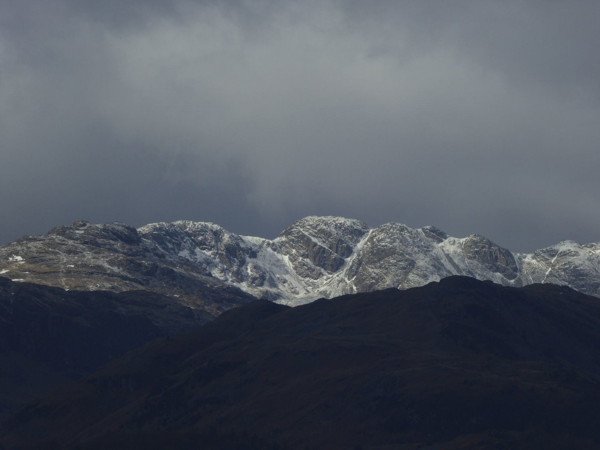
A view into the guts of a piecemeal-collapse caldera, Crinkle Crags, viewed from Waterhead. The layering on show is mainly intra-caldera ignimbrite rotated because the magma chamber roof broke up whilst it collapsed into the vast hole left by explosive eruptions on a massive scale.
As one part of an essentially contemporaneous set of volcanics, the Eycott Group of the north Lakes is much more subdued than the superbly exposed Borrowdales which means that the focus here will inevitably be on their central fells cousins. Formally it is termed the Borrowdale Volcanic Group an umbrella for more than forty formations and a larger number of members. Such stratigraphic complexity is to be expected in a subaerial volcanic terrain with pronounced lateral facies changes and much readily-eroded unconsolidated materials. The Borrowdales are a remarkable volcanic assemblage representing the most intense magmatic event in the entire history of the British Isles. They include the world’s best example of a piecemeal caldera which is superbly exposed having been deeply dissected by glacial processes. Despite regional metamorphism and orogenic overprints the opportunity to look into the volcanic edifices outweighs the problems caused by the later modifications which, through a quirk of how the whole system works, are not great. Many kilometres of granitic sheets generated in the same magmatic event underpin the Borrowdales providing a buttress against the Acadian shortening leaving large areas of the Central Fells uncleaved. In modern settings the products of the youngest eruptions blanket the evidence for the earlier history limiting access which is facilitated in the Lake District. The Borrowdale Volcanic Group has the world’s best-exposed caldera-lake succession and has deposits from the largest known phreatoplinian eruption. Perhaps as many as nine major calderas operated in the upper part of the group some generating very-large magnitude super-eruptions. The icing on the cake is that the interaction between this volcanic bedrock and glacial activity has produced some sublime scenery!
A glance at the geological map of the Lake District shows the dominant position of the Borrowdale volcanics contrasting with the fringe position of the Eycotts in the north and northeast in a much less-rugged poorly-exposed region. For a long time it was thought that the Eycott volcanics were older than the Borrowdales but now they are considered equivalent in age forming under the same extensional tectonic regime in opposing half-grabens. Both are entirely subaerial which has a major influence on their style of volcanological processes. Estimates vary of the Borrowdales thickness but most of them tip the scales at over six kilometres with eight seemingly the upper limit. That is quite a pile of volcanic rock though the five million year time-scale for its growth is not out of the question given the rate of magmatism that the Earth can produce.
The lower half of the Borrowdale volcanics is very different from the upper half and this leads to a broad informal subdivision in stratigraphic terms into two sequences each roughly three kilometres thick. A composite unit, the Birker Fell Formation, is almost all of the basal part. It is about 60% andesite lava flows but the remainder does not have any thick or persistent components that would justify being mapped out over a significant distance so none of them are recognized in stratigraphical methodology at formation level. For the last couple of thousand million years of Earth History magmas reaching the surface have been mostly in the range of basalt to rhyolite. Silica [SiO2] content of chemical analyses is an approximate indication of the classification; basalt 45-52% silica [basic/mafic], basaltic andesite 52-57%, andesite 57-63% [intermediate], dacite 63-71%, and rhyolite >71% [acid/felsic].
The momentous Borrowdale-Eycott volcanic episode began on a small scale yet powerfully. Small because the deposits [Devoke Water Tuff, Whinney Bank, Po House, Greenscoe] are mostly thin and are not found everywhere at the base of the volcanic pile. Powerful because they represent the most energetic of volcanic explosive eruptions. The first volcanic events in the Borrowdales proper were the result of magma passing through Skiddaw Group rocks and coming into contact with ground water in the near surface. If the aquifer contributes the right amount of water the results are highly energetic and lead to maximum fragmentation of the magma in extremely powerful explosions. These are the most powerful volcanic eruptions on the planet and they have some wonderful names. In cases where the heating of the groundwater, and its expansion, are the only causes of eruption it is a phreatic event. At the other end of the spectrum if the magma is fragmented by the expansion of internal volatiles it is a magmatic eruption. For fragmentation caused by a mixture of internal and external sources of components capable of expansion, phreatomagmatic is the term. These earliest events in the Borrowdales are mainly phreatic giving rise to a generally thin and patchy set of deposits which contain fragments of magma and Skiddaw country rock. Careful study of the volcanic fragments proves the origin of the explosivity. If an explosive eruption has no external contribution the pieces of ruptured magma [pyroclasts] are frothy because expanding bubbles have to occupy more than 60% by volume of the magma before the expansion breaks the magma. Bubbles in volcanic rocks are commonly preserved and they may be empty [vesicles] or filled by minerals [amygdales]. For the early phreatic deposits the volcanic fragments have no vesicles which shows that the explosivity was generated by the magma heating external water. The volcanic clasts in the basal Borrowdale phreatic deposits are basaltic andesite.

Early stages of a fissure eruption on the flanks of Kilauea on March 14th 2011. An earlier segment in the forest away from the viewer has become inactive. As yet inactive fractures are towards the viewer. United States Geological Survey, Public Domain.
After the initial volcanic blasts things became generally more subdued when fissure eruptions mainly fed andesite lava flows to create the Birker Fell Formation, a volcanic pile two to three kilometres thick. This significant part of the Borrowdale volcanics was built from multiple fissures feeding low-profile, plateau-andesite lava fields. For many years this part of the succession was interpreted as a series of stratovolcanoes but as long ago as 1977 Roger Suthren showed that there was no evidence for steep-sided volcanoes. Individual lava flows in the lava plateau were sub-horizontal typically tens of metres thick but can be up to 200 m. Flows can rarely be traced laterally for more than five kilometres. Most flows are autobrecciated on their margins which with intercalations of reworked volcanic detritus creates a distinctive landscape. Scarps form on the coherent cores of the lava flows whilst their autobrecciated top and bottom margins, and any intercalated material, weather recessively to form benches. This is a trap topography like a series of steps and is evident over large parts of the lower Borrowdales. Excellent examples are found in a belt from Falcon Crags east of Derwent Water round Castlerigg through to High Rigg in St. John’s in the Vale. A light to moderate dusting of snow leaves the scarps free but accumulates on the benches to emphasise the topographic style. A word of caution is needed here because it is necessary to consider the possibility that some of the andesite sheets were intrusive and hence are sills. For the majority of the Birker Fell Formation it is likely that sills are very much the minor component but locally they become important as at Honister.

Birker Fell Formation on High Rigg as seen from St. John’s in the Vale. The crags are the hard resistant cores of andesite lava flows whilst the benches are a more-easily eroded mixture of autobrecciated flow margins and interbedded volcanic detritus.
An autobrecciated top of an andesite lava flow in the Birker Fell Formation on the slopes of Pike o’ Blisco, NY 27736 03273. Laminated sedimentary material was washed into the spaces between the blocks after the lava stopped flowing. Careful analysis in the field is needed to discriminate between peperite at the top of a sill and the top of a blocky lava flow.
Rather than being completely uniform the andesite sheets do have some variations. Many Birker Fell andesites are flow-banded displaying intricate folds and refolded folds of the banding. The recessed layers are more crystal-rich and are slightly more basic than the proud layers. During magma ascent, and whilst the lava flows over the Earth’s surface, repeated episodes of fracturing, healing, and attenuation, in the flow, stretch out pockets of different texture to create banding. Flow banding was once thought to be created by segregation of phenocrysts and microlites during magma flow. On close inspection the bands are seen to have ragged margins. Flow banding is normally weakly defined but can be emphasised by weathering to be nearly as well developed as bedding in sedimentary rocks. Composite lava flows are a minor component of the Birker Fell Formation. Typically these have an andesite lower part and a basaltic andesite upper with a zone of interlayering at the interface. It is believed that the two magmas were erupted together through the same vent after the more basic magma intruded into a chamber containing the andesite; the magmas failed to mix/blend before eruption.
Isoclinal folding and refolding of flow-banding in an andesite lava flow, Birker Fell Formation on Harter Fell SD 21733 99619.
The lower part of the BVG contains examples of many types of volcanic behaviour but to provide background information on all of them would tilt the discussion towards a volcanological textbook hence only brief explanations of the minor styles of explosive activity will be given. Fuller accounts will be given when they are the major players. Plateau-andesite lava fields are not that interesting topographically but there was some variety in Birker Fell times amounting to 40% of the total thickness including a’a basalt flows, thick dacite lava flows, and felsic ignimbrites deposited by pyroclastic density currents. These currents, created by highly explosive eruptions, are mixtures of gas, magma fragments, and rock fragments, that move down-slope because they are denser than the surrounding atmosphere. None of these in the Birker Fell was on a large scale but some were sufficiently extensive to form useful marker horizons within what would have otherwise been a very featureless pile of andesite flows. One distinctive unit is the Little Stand Tuff is a rhyodacite ignimbrite which can be traced laterally for 16 km. The usage adopted here is that an ignimbrite is any deposit from a pyroclastic density current. Besides contrasting with the dominant andesitic composition most exposures have lithophysae – spherulites with a central vug. As is the case for spherulites, lithophysae are characteristic of high-temperature devitrification of coherent silicic glass and are found in formerly glassy lavas as well as welded pyroclastic deposits [ignimbrites]. They begin to grow at an early stage in the cooling history, when the hot glass is still able to deform plastically involving nucleation of spherulites on small vesicles. As spherulitic crystallization proceeds, the vesicles are expanded by exsolving volatiles. The vugs vary from circular to star shaped and may remain open or be fractures or filled with minerals such as agate or chalcedony. Lithophysae range up to larger diameters than spherulites, rarely reaching a few tens of centimetres across.

Lithophysae [4-6 cm] on a joint face in the Little Stand Tuff on Harter Fell SD 21880 99869. On weathered surfaces they are typically positive nodules.
Several other ignimbrites occur in the Birker Fell. These are all thin apart from the Craghouse Member in the Western Lakes which is an andesitic to dacitic welded ignimbrite up to 1,100 m thick even though it occupies a limited area. It is interpreted as being the product of a caldera eruption and is the first of this style of events in the Borrowdale volcanics which will be covered more fully when we look at the upper BVG. A distinctive felsic component of the Birker Fell is the Great Whinscale Dacite [GWD] which is a lava flow that has been traced for 13 km implying high eruption temperatures for a composition that would normally be highly viscous. The most distinctive aspect of the GWD is the prominent flow-jointing throughout its bulk. Autobrecciation is well developed on the GWD base and above that a couple of metres has flow-folded flow-banding. A narrow zone at the top can be amygdaloidal.

Prominent flow joints in the Great Whinscale Dacite, Birker Fell Formation, Harter Fell SD 2196 9982.
Locally in the Birker Fell Formation there were sizeable lakes which accumulated volcanic fragments washed into these low points by streams in the bare volcanic landscape. With much ash and larger volcanic fragments being available these easily eroded materials were also probably involved in subaerial debris flows [lahars] to add to the fluvial transport. The Eagle Crag Member is the largest lacustrine deposit outcropping over a 15 km strike length and is up to 270 m thick. It is impossible to say much about the size and distribution of the lake or lakes. There may have one large lake or several lakes distributed in space and time throughout the outcrop of the Eagle Creek Member. What is certain is that the lacustrine sedimentary accumulation was sufficiently thick to prevent multiple andesite sheets from reaching the surface to form lava flows. Prior to the most recent assessment of these andesite bodies they were interpreted as blocky andesite lava flows. In the late 1970s very high-level intrusions were recognized for what they are despite their sheet like morphology and their bedding conformable relationships. This sparked a debate about how many similar andesite sheets were sills rather than effusive and prompted field geologists to look for evidence to prove the mode of emplacement which for the typical exposure conditions can be difficult. If definitive evidence is lacking then the term andesite-sheet should be used. On Fleetwith Pike a trap-style of topography looks at a distance like much of the Birker Fell plateau-andesite lava field but in this case the step pattern is created by alternations of andesite sills and lacustrine sedimentary rocks. Because the sediments were unconsolidated when the andesite magma was moving towards the surface, the magma was denser than the sediment and there was insufficient buoyancy to get the magma to erupt. It therefore intruded but in doing so set up a huge contrast between magma at nearly 1,000oC and sediment not far from zero degrees. The heat energy from the magma is transferred to the pore fluid in the sediment which then wants to expand massively whilst at the same time the magma is being chilled by the cold wet sediment so it contracts and fractures. Contraction of the magma provides space for the pore fluid to expand and fluidized sediment is forced into the broken magma. The end-product is an in-situ mixture of usually angular igneous fragments in a sedimentary matrix known as peperite. These textures form on the margins of a peperitic intrusion and are well seen on several andesite sheets at Honister.

Top of a peperitic andesite sheet, Birker Fell Formation, Hopper Quarry, Honister. To highlight the definition of the andesite fragments the image contrast has been massively increased. Floating andesite pyroclasts are the most common feature and near the centre of the photo they form a tower which was an offshoot of the sill which broke up in-situ. Rucksack 55 x 35 cm.
Peperite from Birker Fell Formation, Honister. A dark andesite pyroclast has calcite and sediment filled amygdales. An array of sediment filled amygdales near the centre in part shows the feeder fracture with a very narrow sediment infill but for some of the array the feeder fracture has drained of sediment and healed because of the residual heat in the andesite. Sediment in some of the amygdales has vesiculated because of the heat from the igneous host. Photo: Barry Marsh.
We now come to the upper half of the BVG when Nature decided to unleash hell at a boundary that is marked by a change from dominantly effusive volcanicity to massive-scale violent explosivity. Terms like catastrophic, colossal, cataclysmic, stupendous, and paroxysmal, are appropriate to convey the magnitude of these events. It was a most violent few million years with many huge-volume and devastating pyroclastic currents sweeping the central Lake District. This sustained extreme explosivity involved multiple large calderas and produced one the world’s best collections of caldera volcanoes. A volcanic caldera is a topographic depression formed by sub-vertical subsidence into a magma chamber partly drained by an explosive eruption. Some calderas can grow stratovolcanoes within the depression but this is not a necessary part of their evolution and many calderas have no evident volcanic morphology.
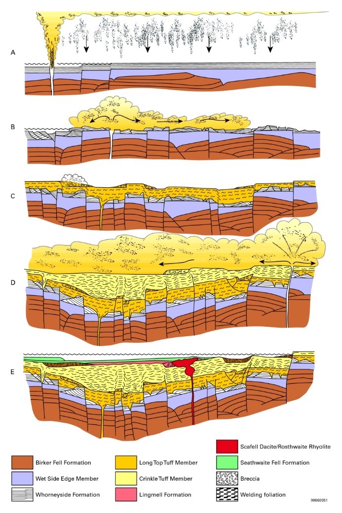
Schematic cross-sections showing development of the Scafell Caldera during piecemeal collapse. The sequence of events is greatly simplified (after Branney and Kokelaar, 1994). [A] Emplacement of the Whorneyside Formation ignimbrite and succeeding phreatoplinian ash. [B] Onset of piecemeal subsidence causing deformation of the Whorneyside deposits; burial beneath hot silicic ash of the Long Top Tuffs erupted from new vents. [C] Further collapse causing ductile deformation of the hot ignimbrite. [D] Paroxysmal eruptions producing very densely welded ignimbrites of the Crinkle Tuffs and causing renewed subsidence and fault-scarp collapse. [E] Waning eruptions and silicic dome emplacement; sedimentation in a caldera lake. P916050 Earthwise. Figure 20 in Stone, P, Millward, D, Young, B, Merritt, J W, Clarke, S M, McCormac, M and Lawrence, D J D. 2010. British regional geology: Northern England. Fifth edition. Keyworth, Nottingham: British Geological Survey.
Because of its superb 3D exposure, and greater level of documentation, the Scafell Caldera will be used to illustrate this volcanic style in the BVG. Its map outline defines an ovoid 17 x 14 km with an area of over 150 km2. Initially andesitic explosivity was mainly driven by expansion of volatiles in the magma. Because magma was being drained from the subsurface, the magma chamber roof responded to the removal of support by collapsing creating extensive fractures many of which tapped magma. Rather than tree-trunk like eruption columns from circular vents, the fractures fed curtains of fragmented magma, gas, and pieces of pre-caldera rocks. A gas thrust provided by expanding volatiles can project erupted materials at speeds up to 2,000 km hr-1. Further up the eruption curtain the gas thrust loses its power and if the erupted material is not to fall back to Earth the curtain of material has to become buoyant. It does this by entraining ambient air and heating this in contact with the pyroclasts, and the magmatic volatiles, to carry the pyroclasts to great heights and to eventual dispersal down-wind when buoyancy runs out. In this first large-scale explosive event in the BVG the eruption curtains were not driven to great heights and fountaining cascaded the erupted solids and gas downwards in pyroclastic density currents [PDCs] to bury the pre-caldera landscape in an ignimbrite sheet that was probably much more than the presently preserved volume of 20 km3. Stratigraphically this is the Wet Side Edge Member of the Whorneyside Formation, an andesitic welded tuff. Welding is a widespread feature of BVG ignimbrites highlighting the high concentration of the PDCs which would have retained heat during transport and deposition. It is a surprise to many to hear that these are sedimentary deposits but the definitive work on the topic is entitled “Pyroclastic Density Currents and the Sedimentation of Ignimbrite” by Mike Branney & Pete Kokelaar. Having been deposited hot, the retained heat allows the ignimbrite to plastically deform under the load of its own weight; a compaction process that takes place in hours to days. In some circumstances the magma fragments may be so hot that they deform on landing. Most of the compaction occurs in inflated [vesicular] magmatic fragments and takes place by reducing the vesicles in the vertical dimension. For a magma to blow itself apart by expanding its own volatiles the vesicularity has to be over 60% making it pumice and in the most violent eruptions it is well above that level. Fragments of the magma are known as juvenile whereas fragments of pre-eruption rocks are lithics. Frothy juvenile fragments are ragged in outline but commonly are rough spheres and when they are compacted they have ellipsoidal shapes known as fiammé from the Italian for flame. Extreme compaction can flatten pumice so much that it may be impossible to recognize the ignimbritic origin and then debate ensues as to whether the unit is pyroclastic or a lava flow. Returning to the Wet Side Edge Member it is a weakly- to moderately-welded andesitic ignimbrite whose correct rock type name is lapilli tuff reflecting its poorly sorted nature. Eruption columns/curtains are turbulent as are PDCs and this origin and transport keeps a wide size range of fragments supported resulting in a poorly sorted deposit; lapilli is for fragments 2 to 64 mm and the tuff part of the name is for particles less than 2 mm.
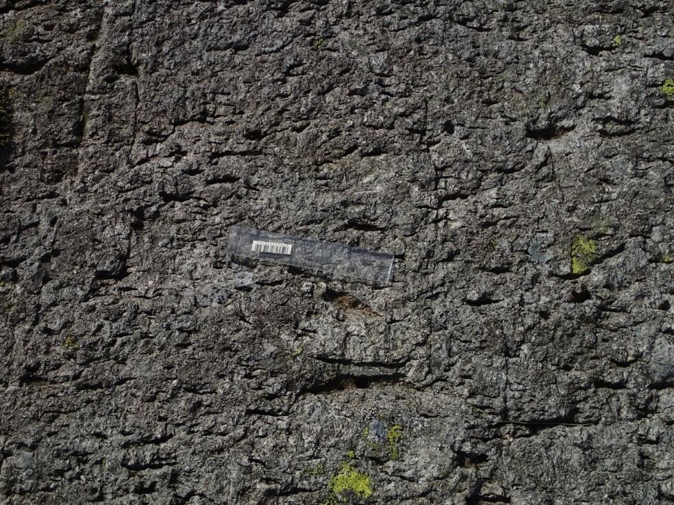
Wet Side Edge Member displaying a moderate welding fabric defined by flattened vesicular andesite fragments, west slopes of Stonesty Pike. 15 cm ruler for scale.
An even more dramatic phase of the Whorneyside eruption completed the andesite explosivity. Several tens of km3 of water accessed the andesite magma which didn’t put the fire out but by adding steam explosivity drove the eruption to unprecedented heights of violence. Under these conditions we have an intense fragmentation mechanism now acting on a large body of magma leading to a dramatic change in the eruption style. The low-column fountaining of the Wet Side Edge Member was transformed into a phreatoplinian eruption adding considerably to what was already a vigorous event and sending up an eruption column several tens of kilometres in height. Well over 100 km3 of erupted material was dispersed in a cloud when buoyancy in the eruption curtain was lost and the landscape was covered in a very distinctive deposit, the Whorneyside bedded tuff. Because of the vast amounts of water that had been involved in this phase of the eruption the dispersing cloud was very damp. This moisture content stuck particles together so they fell out of the cloud prematurely. On landing this process creates an instantly recognizable style of deposit where parallel beds have almost perfect uniformity. Such airfall deposits are well sorted if the eruption was driven by volatiles in the magma but, with phreatoplinian examples, the sticking together of particles results in a poorly sorted tuff. Another expression of the dampness in the system is that accretionary lapilli are common. These are ash aggregates that typically have a structureless core with a much finer grained rim with or without concentric laminations. It is likely that the Whorneyside eruption took place over a period of weeks to a few months because there is little evidence for significant erosion of the bedded tuff which would have had virtually no ability to resist erosion. Small-scale erosional rills give evidence for minor breaks in the airfall process and these are to be expected because the damp conditions in phreatomagmatic eruptions create their own rainfall. Fairly common impact sags from centimetre sized lapilli show a ballistic component to pyroclast transport.
It can be readily demonstrated that caldera-collapse started with the Whorneyside eruption because the layering in the bedded tuff provides an excellent marker for soft-sedimentary deformation induced by block rotation during the initial piecemeal breakup of the magma chamber roof. Where packages of layers slip the headwall will be an area of tension forming extensional faults and the toes of slides will be in compression where thrust faults will be produced as on Stonesty Pike.

Parallel-bedded Whorneyside tuff on Stonesty Pike NY 2487 0403. The prominent layer a quarter of the way up the crag maintains a very consistent thickness as do some thin pale layers above it showing airfall characteristics. The prominent layer is duplicated on the left-hand side by thrust faults showing that the layers have been contracted during piecemeal caldera collapse. The rucksack is 50 cm tall.
After a relatively minor andesitic start to the Scafell Caldera’s life, the system became dominantly felsic producing huge volumes of rhyolitic ignimbrite in possibly six closely-spaced or semi-continuous eruptions each probably more than 100 km3 in volume. These are bordering on supereruption territory and perhaps achieving that accolade when we realise that we only have a clear record of the explosive products that were trapped within the caldera. These are prodigious amounts of fragmented magma. For many large ignimbrite eruptions the volumes of intra-caldera and outflow deposits are typically sub-equal so doubling the observed quantities to get an overall estimate is not unreasonable. On the northern margin of the Scafell Caldera around Seathwaite the caldera faults tapped rhyolitic magma before andesitic explosivity had ended so there is a zone of alternating rhyolitic and andesitic ignimbrites. In the south of the caldera there is sharper distinction between the two compositions and the boundary is marked by an angular unconformity. Mention of this type of gap in the depositional record might bring to mind Huttonian thoughts of millions of year lost but bear in mind the rapidity of volcanological processes. After the 1991 Mt Pinatubo eruption 200 m stacks of ignimbrite were eroded in ten years and individual major-eruption phases in a caldera may take place over weeks to months which would include the roof collapses, piecemeal or otherwise. In the south the first silicic ignimbrite marking the start of the Airy’s Bridge Formation, the Stonesty Tuff, is well stratified and rests with angular discordance over Whorneyside bedded tuff. Pronounced layering in an ignimbrite is an indication that the PDC was dilute. The deposit also contains accretionary lapilli which is an indication that the explosivity involved water to provide the moisture to stick together highly-fragmented ash particles. The Stonesty is one of four similar horizons in the Airy’s Bridge Formation; they are very thin, rarely thicker than two metres, all are well stratified, and low-angle cross stratification is common. The sedimentary structures formed under upper flow regime conditions common in PDC settings but not so common in epiclastic environments. Despite being very thin these tuffs form marker horizons that can be traced long distances, the Stonesty having been mapped for over 20 km.
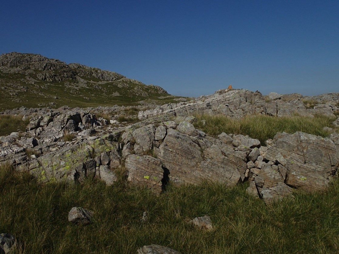
NY 24855 04111 Angular unconformity between the andesitic Whorneyside bedded tuff and the overlying pale-weathering rhyolitic Stonesty Tuff the basal component of the Airy’s Bridge Formation. Timescales are unknown but probably were of the order of years to decades because the unconformity was created by block rotation during piecemeal caldera collapse.
The Airy’s Bridge Formation at its maximum is around 1,000 m of dacitic to rhyolitic lapilli-tuff emplaced by PDCs to create a thick pile of ignimbrites of varying characteristics that allow correlations in faulted discontinuous outcrops. Welding of the ignimbrites is a pervasive feature and locally, as in the Bad Step Tuff, it is so intense that it was interpreted as a flow-banded lava flow until the most recent phase of investigation. If pyroclastic density currents are highly concentrated they retain heat which leads to high degrees of compaction, thinning the fiammé to such an extent that they become thin streaks which means that it is rare to see the fragmental texture and the flattened fiammé take on a flow-banded appearance. PDCs that retain heat also create another lava flow type of structure because their deposits can be columnar jointed. Reading John Ruskin’s account of studying columnar cooling joints in an ignimbrite above Coniston thinking it was a lava flow makes you realise how fascinated he would have been to have known their true origin. Another feature of these very-high temperature ignimbrites is their ability to start flowing like a very very sticky lava, again showing how difficult it is to differentiate between high-grade ignimbrites and lavas. Welding fabrics that are moderately developed are termed eutaxitic whereas highly welded examples are parataxtic. If the latter style is folded it is rheomorphic which happens if the ignimbrite is deposited on a slope or is tilted by caldera collapse whilst still hot.

Simplified stratigraphy of the Scafell Caldera in the Borrowdale Volcanic Group from Brown et al. (2007) based on Branney & Kokelaar (1994).

Pumice fragments from an Airy’s Bridge Formation welded ignimbrite. Hydrothermal alteration has changed the colour of the fiammé relative to the matrix. The ragged ends show the degree of vesiculation of the pumice fragments and a rough estimate of the compaction can be gained by assuming the fiammé were approximately spherical during transport. Feldspar phenocrysts are visible in the fiammé. Loose block on Crinkle Crags etched by acidic peat water, NY 25944 04122.
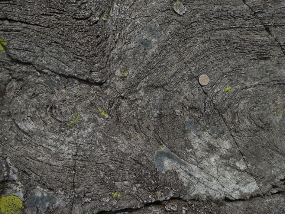
Rheomorphic folds in Bad Step Tuff south of Esk Pike. The folded surface defining the shape of the folds is an intense welding fabric. 20p coin is 21.4 mm in diameter.
Some calderas are produced by evacuating magma from a single zoned magma chamber but the early studies on the Scafell Caldera showed at least the involvement of silicic and andesitic bodies. Further complexity for the active magma reservoirs has been demonstrated in several student projects from the University of Leicester. It is yet to be determined if these variations were caused by a set of separate magma chambers or multiple melt lenses within a largely crystalline mush. Three different sources were required to explain the chemical compositions seen within the explosive products of the Scafell Caldera.
A depression 17 x 14 km and hundreds of metres deep was left when the violent explosions were over. This filled with fresh water rapidly to form an Ordovician Lake District with perhaps another large lake present at the same time as well as many smaller lakes scattered around. Our present meres, waters, and lakes, would be dwarfed by the approximately 150 km2 lake; for comparison our largest, Windermere, is 15 km2 and the deepest, Wastwater, has a mean depth of only 40 m. All around the Scafell Caldera lake were large volumes of loose fragmental volcanic detritus that was readily transported by fluvial and debris flow processes into the lake. The end product is a 500 m thick pile of sedimentary rock almost entirely composed of volcanic fragments that is probably the world’s best example of a caldera-filling succession, the Seathwaite Fell Formation. An added bonus is that most of this lacustrine deposit sits on top of the thickest part of the Lake Distict Batholith so it was largely protected from the distorting overprints of the slate-belt Acadian Orogeny. Sedimentary structures are superbly preserved and many places have exposures of stunning clarity. Detailed sedimentology has been carried out on these lake deposits and we have in-depth knowledge of how the lake filled. A number of distinctive subdivisions have been recognized within this sedimentary succession. In places large deltas built out from where rivers fed detritus into the lake, contrasting with widespread turbidite deposits that are dramatically displayed in cleaved and uncleaved areas. It is a remarkable feature of the slates that, when viewed looking onto the cleavage plane, the most delicate of structures are preserved and possibly accentuated. Magmatic activity did not entirely cease during the infilling of the caldera. In the earliest phase, a lava dome [the Scafell Dacite] grew on the west and northwest side of the caldera. This is a sticky lava hence did not flow far from the vent which probably was on a caldera bounding fracture. The lacustrine sediments lapped onto the autobrecciated top of the dome and filtered down to fill the cracks and eventually these deposits covered the dome.

An example of preservation of delicate sedimentary structures in lacustrine deposits in the BVG; Seathwaite Fell Formation [Cockley Pike Member] on Seathwaite Fell. Elutriation channels at the top of a turbidite bed were formed when the loose, depositional grain-fabric collapsed to expel large quantities of pore water soon after the deposit formed. Field of view approx. 80 cm.

Soft-sedimentary deformation in the Seathwaite Fell Formation on Scafell Pike [NY 21310 06968]. Volcanic-related seismic shock is the most likely cause of the disruption but structures like this can result from the arrival of an overlying thick bed rapidly increasing pore fluid pressure. The disturbed bed is about 20 cm thick.
Sporadically, explosive-eruptions in the region deposited pyroclastics in the lake mainly on a small-scale but with one notable exception, the Pavey Ark Member. Near Grasmere on the edge of the Scafell Caldera an andesitic explosive eruption more than 5 km3 in volume directed a PDC westwards. The denser larger-part of this PDC sank into the lake creating a coarse deposit up to 125 m thick that retained heat despite being under hundreds of metres of water. Evidence of heat retention is seen in large pyroclasts in the deposit that plastically deformed during transport, deposition, and burial. These clast are called rags which are well seen on Pavey Ark, the locality that has given its name to the deposit which can be mapped throughout most of the Seathwaite Fell Formation. If you stand by the outlet of Stickle Tarn and look up to Pavey Ark, most of the crag is spatter-bearing ignimbrite and perhaps the most impressive aspect is that the whole deposit was emplaced in a matter of hours.
A folded spatter rag [approx. 40 cm across] in the ignimbritic Pavey Ark Member of the Seathwaite Fell Formation NY 28101 07719.
The final phase of filling the Scafell Caldera was marked by a transition back to subaerial conditions when one of the largest tuff rings yet documented worldwide created the Glaramara Tuff. This style of volcanic landform is produced when magma meets groundwater in the shallow subsurface. Intense magma fragmentation is the hall mark of such environments coupled with abundant ash aggregates because of the moisture content of the PDCs. Despite being a thin deposit normally less than 20 m it covers an area of 80 km2 and the effects of the eruptions may have affected an area of 800 km2. Intervals between explosions are hard to quantify but the behaviour of tuff rings is mainly controlled by the time taken for sufficient groundwater to recharge. Taal volcano is of this style and since the 1500s it has erupted 26 times to give an idea of repeat intervals. For the Glaramara Tuff each major pulse is believed to have formed eruption columns of a few kilometres in height which collapsed to generate dilute PDCs which had runouts up to 12 km. This style of PDC leads to well stratified ignimbrite containing high concentrations of accretionary lapilli. Another common feature is cross-stratification of an upper-flow regime style. Several other tuff ring deposits have been identified in the BVG including Ghyll Scaur Quarry near Millom and Raven’s Crag near Kiln Bank Cross.
Upper flow regime cross-stratification [approx. one metre high] in basal Caw Formation on Ravens Crag [SD 22405 92510]. The lower 20 m of this formation at this locality is stratified ignimbrite containing abundant accretionary lapilli. Layers on the left truncate those on the right until towards the top where they are continuous over the dune. Current flow in the PDC was from left to right.
At about the same time as the Scafell Caldera was active it is likely that another large caldera was being formed in the Haweswater district. Subsequent to this initial phase of large-magnitude mainly-silicic eruptions, five more major eruptive periods completed the BVG succession. Much of this activity involved caldera-forming eruptions. Details of these events are not presented here though a good level of detail can be found in Millward, 2004, Proceedings of the Yorkshire Geological Society, vol. 55, pp. 73-105. Some authors believe that the final magmatic event was the emplacement of the Lake District Batholith though others believe that major components of the batholith were synchronous with various caldera episodes. The latter view is based on the spatial relationship between the calderas and the batholith because the intrusions underly the volcanic centres. In contrast those in favour of the batholith being post-volcanic believe that if the granites had been emplaced earlier they would have promoted uplift which would have led to the erosion of much of the BVG. Geophysical data have defined the shape and thickness of the granitic intrusives. The batholith is a collection of stacked tabular granitic sheets reaching a maximum thickness of around 10 km. Parts are exposed in the west where several components have been mapped including the Ennerdale intrusion and the Eskdale pluton. Each of these is composite. The Eskdale pluton comprises three textural varieties of granite and has a minor granodiorite phase. The Ennerdale intrusion is mainly a granophyric granite with a slightly porphyritic texture but it has two minor diorite components. Radiometric isotope studies for the exposed part of the Lake District Batholith give robust ages [452 ± 4 Ma, 450 ± 3 Ma] but the uncertainty means that this approach cannot resolve the debate about the syn- or late-volcanic timing. Minor intrusions, mainly dykes, related to the volcanic episode are common throughout the Lake District.
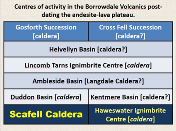
A very broad-brush set of correlations and volcanological interpretation for the upper part of the Borrowdale Volcanic Group emphasizing the extent of caldera-related volcanism.
VOLCANOTECTONIC FAULTS
With such a collection of calderas it should be no surprise to learn that the BVG is highly faulted. Many faults can be demonstrated to have been active during the massively explosive caldera-forming eruptions because mappable ignimbrite units on either side of the faults have different thicknesses. Other features can be used to prove syn-caldera timing including ductile deflections of welding fabrics into fault zones showing that movement took place whilst the ignimbrite sheet was still hot. Because the overall stratigraphy is typically gently-dipping these deflected zones of welding fabric are subvertical. These zones can be broad as seen in the Langdale Caldera about 350 m WNW of Blea Tarn where a 70 m wide belt of Side Pike Ignimbrite is characterized by very steeply dipping parataxitic foliation. A common lament amongst those mapping in the Central Fells is that Acadian faults, with little offset, are typically highly visible in the landscape as deep troughs yet much more significant volcanotectonic faults, in terms of displacement, have very little expression. Though the lament is justified in most cases there are exceptions as seen at Grave Gill overlooking Mickleden where a deep gully has been eroded along a volcanotectonic fault. The Bad Step Tuff of the Airy’s Bridge Formation thickens across this fault from 300 m to >490 m. Brittle reactivation of this fault involving a few tens of metres of displacement might be why it has an Acadian-like expression?

Deflection of the gently dipping welding fabric in a rhyolitic ignimbrite to near vertical adjacent to a volcano-tectonic fault formed during caldera collapse. The ignimbrite was still hot during the deformation of the fabric as demonstrated by the ductile nature of the deflection. Airy’s Bridge Formation in the Scafell Caldera on Crinkle Crags NY 24815 04417.

A view towards the north to the Langdale Pikes with the geology overlain. Highlighted is the Grave Gill volcanotectonic fault which has very different thicknesses of the Bad Step Tuff, Airy’s Bridge Formation, on either side showing that it was active during caldera collapse. SCLSR – Scafell Caldera Lake Sedimentary Rocks. Based on an interpretation by Peter Kokelaar.

A view towards the north to the Langdale Pikes without the geology overlain.
For a long time the nature of the unconformity above the Borrowdale volcanics caused much debate. In many places it is a pronounced angular unconformity and such relationships are typically associated with orogenic activity. We now know that the marine planation, that took place as the basal Windermere Supergroup was being deposited, was truncating the jumbled mass of fault blocks created in the multiple caldera-collapse events that were so common in the upper BVG. This readily explains the angular unconformity.
MINERALIZATION
Some mineral deposits in the Lake District are very clearly syn-volcanic. The graphite mineralization at Seathwaite in Borrowdale is one of only two deposits of this type worldwide in that they are hosted by volcanic rocks. Of great historical interest because mining started in the 1500s the graphite was important for casting cannonballs, for coin moulds, and the famous pencil industry of Keswick. The graphite orebodies are pipe-shaped because they were localized along the intersections of fractures within a dioritic intrusion within the Birker Fell Formation. Though post-Birker Fell in age the graphite was precipitated during the evolution of the Borrowdale Volcanic Group. The mineralizing fluid reacted with the host rocks to reach carbon supersaturation thus forming the ore deposit. Copper mineralization in the Lake District was also syn-volcanic as proved by its location in volcanotectonic faults and the cleaved nature of the copper-bearing veins showing they pre-date the Acadian Orogeny. These deposits are also of historical significance because in the reign of Elizabeth I the approach to mining was transformed by the arrival of miners from Germany mainly to exploit copper.

A summary tabulation of mineralizing events in the Lake District. Adapted from: Mines in Cumbria by Michael Dewey, Cumbria RIGS.