
QUATERNARY

QUATERNARY
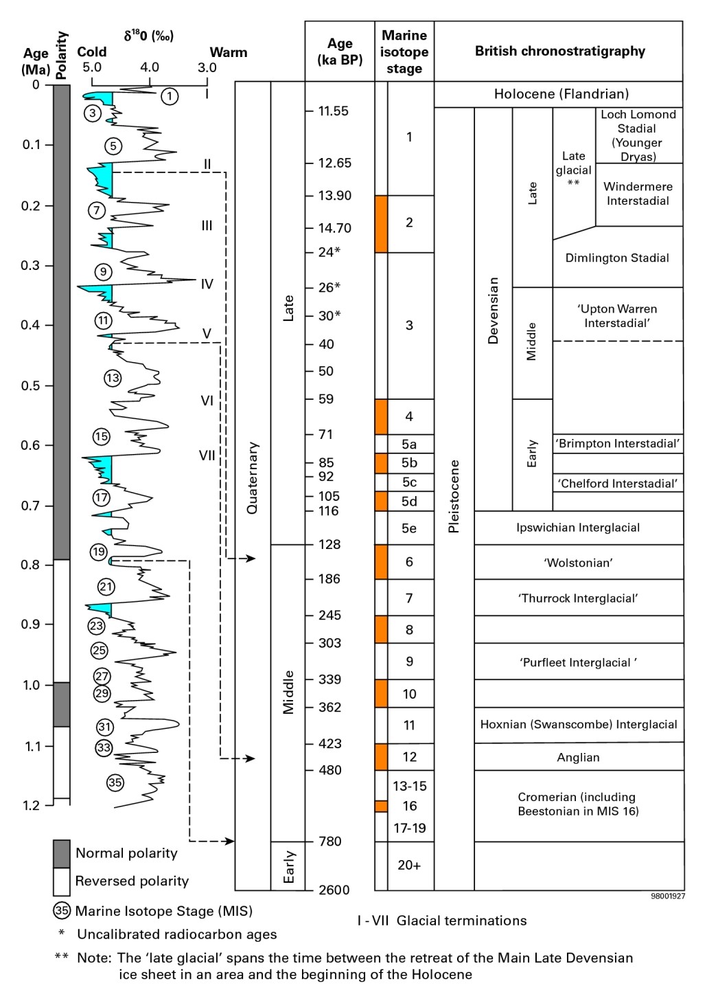
British Quaternary chronostratigraphy, geomagnetic polarity and a representative oxygen isotope record (ODP 677) from the North Atlantic tuned to orbital timescales. Figure 64 in Stone, P, Millward, D, Young, B, Merritt, J W, Clarke, S M, McCormac, M and Lawrence, D J D. 2010. British regional geology: Northern England. Fifth edition. Keyworth, Nottingham: British Geological Survey.
The Quaternary history recorded within the Lake District is a vivid example of how poorly terrestrial environments preserve evidence of even quite significant events. This might come as a surprise to many who are impressed by the magnificent glacial scenery of the region. Out in the ocean basins continuous sedimentation has locked in a complete record of climate change in the last 2.58 myr documenting around 50 major cold/warm fluctuations and continuous ice cores provide detail for the last 800,000 years. In contrast, in the Lake District, beyond the last glaciation, we struggle with patchy evidence for perhaps two of the earlier cycles. Fragmentary doesn’t even begin to convey the paucity of the record provided mainly because the last ice sheet did such a comprehensive job of wiping out evidence of the earlier events. The indelible mark left by the erosive work of glaciers in the Central Fells does not happen overnight. It has been estimated that glacial valleys deepened at a rate of around a metre per thousand years; some in the Lake District are 600 to 700 m deep which suggests the valleys may have been occupied by glaciers for a third of the Pleistocene and we have evidence for less than ten percent of that time. Within the Lake District National Park Ice Age effects are totally dominated by erosive processes and any in-depth consideration of depositional settings has to look outside the park boundaries. Most impressive of the features that make up the glacial topography in the Lake District are the glacial troughs traditionally referred to as U-Shaped valleys but many object to this nomenclature as they are commonly parabolic in section. In addition to the glaciated valleys the erosion-based scenery in the Central Fells is a composite of many elements including cirques, arêtes, hanging valleys, over-deepened troughs filled with lakes and tarns, truncated spurs, roches mountonnées, meltwater channels, and broad areas of ice-scoured terrain.
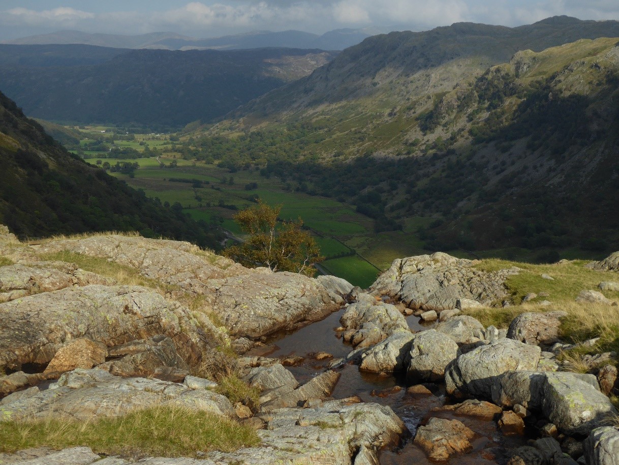
A classic hanging valley where Sourmilk Gill leaves Gillercombe and plunges into Borrowdale at Seathwaite.
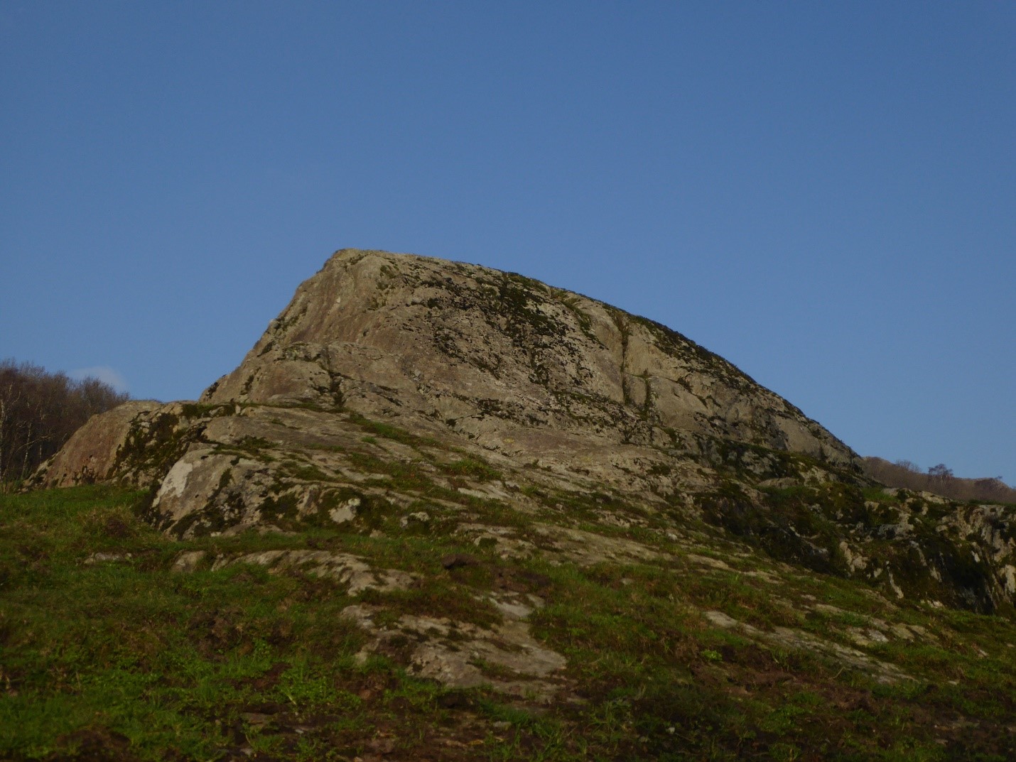
An elegant roche mountonnée in Dunnerdale looking a bit like a mini Yosemite Half Dome. Ice flow from right to left down the Duddon Valley. The steep downflow side is defined by tectonic joints in the bedrock to add to the near perfection of the shape.
Going back to before any ice accumulated in the Lake District, there was a drainage system that had been established on very gently domed Chalk. Many publications attribute this doming to the buoyancy provided by the ten kilometre thickness of granite under the Borrowdale volcanics though recent work claims the fundamental faults defining the Lake District Block are a greater control on uplift. Whatever the cause of the dome, the river system created on the Chalk removed that unit entirely from the Central Fells together with any other Mesozoic rocks which were mainly Triassic. Once through the cover and into the Lower Palaeozoic rocks, the drainage system encountered a wide array of fractures which focused erosion. The end product is a crudely radial pattern which does not radiate from a point and which has an east-west drainage divide giving rise to it being dubbed a “caddy spoon” pattern. Today’s impressive glacial landscape owes much to the control exerted by the fracture pattern in the basement rocks and glaciers only locally took short-cuts and even these were mainly on secondary fractures. It is often said that bedrock lithology is the greatest control on topography but fractures [joints and faults] are possibly as important. The first ice accumulations thick enough to start flowing under gravity would have been funneled along the valley system that had been guided by the fractures in the Lower Palaeozoic rocks. Given the time constraints dictated by erosion rates, glaciers must have started their work in the Early Quaternary when 40 ka cycles dominated the climate swings from cold to warm. The earliest glaciations would have been ice caps centred on the high Lake District Fells and, though we have no direct evidence, it is unlikely that this local ice merged with ice from other centres, such as Scotland, to form an ice sheet. Dramatic ice sheets are minor contributors to landscape evolution; most erosion took place during the much longer periods of mountain glaciation when conditions were not cold enough to support ice sheets. Even when the Lake District was totally inundated by ice sheets, as in the last main glaciation, local radial ice flows were sufficiently strong to prevent ice from other regions entering the mountainous areas; this is evidenced by the lack of Scottish erratics in the Lake District.
In Cumbria the first direct evidence for glacial activity is the deposits of the Mid-Quaternary Thornsgill Till Formation which is found between Keswick and Penrith. This unit is believed to have formed in the Anglian Stadial between 423 and 480 ka BP and provides evidence for the existence of an ice cap at this time centred on the Lake District. Another fragment of evidence for glaciation prior to the main event has only been found in boreholes around Sellafield and Drigg on the Cumbrian west coast. This area has a complex glacial history having repeatedly been a battle ground between Scottish and Lake District ice. The drilling discovered glacial materials [Drigg Till Formation] underneath lake deposits shown to be Early Devensian in age. The Drigg till contains clasts from the Borrowdales as well as Scottish granites which proves it to be the product of an ice sheet where Scottish and Lake District ice converged. Its stratigraphic position suggests a Wolstonian age somewhere in the interval 128 to 186 ka BP. Another consequence of this discovery is that the classic Wasdale glacial trough was already well established so it shows that the last main glaciation merely applied the finishing touches to the magnificent glacial scenery of the fells. All other glacigenic materials in the Lake District belong to the Devensian cold stage which began 115 ka BP following the Ipswichian Interglacial. Though the Early Devensian was a long cold period, only briefly interrupted by interstadials, it appears to have been a time of limited glacial influence. It was not until about 60 ka BP that a short-lived ice cap developed and was able to reach the present-day west coast where again limited evidence is found in boreholes at Sellafield and Drigg. There are no Mid Devensian deposits in the Lake District. Almost all of the glacigenic deposits in Cumbria are from the Main Late Devensian [MLD] Glaciation [Last Glacial Maximum – LGM] which was the subject of a major research project [BRITICE] concentrating on the demise of the British Irish Ice Sheet [BIIS]. This ice mass reached its maximum areal extent by 27 ka BP and the Lake District was ice free by 15 ka BP. In the LGM complex ice flow patterns have been determined by gathering all the evidence from the distribution of erratics, glacial striations, till fabrics, and ice-sculpted landforms such as drumlins. Scottish ice made significant inroads into the Cumbrian lowlands before the flow from the Lake District ice cap asserted itself and repelled the incursion. This sequence is documented in the record of tills in the Vale of Eden which initially is dominated by Scottish clasts but then this ice was displaced by ice from the Lake District ice cap which lost its independence. More than this it pushed down the Vale of Eden and around the north of the Lake District to deflect the Scottish ice stream and set up the battle ground along the Cumbrian west coast between local and imported ice. A by-product of this coalescence is it has created a fantastic place for budding geologists to test their rock identification abilities.
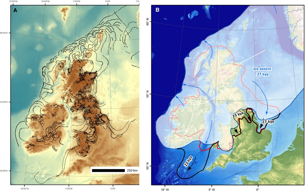
A. Reconstruction of the pattern of retreat for the British–Irish Ice Sheet inferred from data in the BRITICE V.2 database, including moraines, meltwater channels, eskers and subglacial bedforms. B. Overview of the ice sheet at its maximum, noting that it reached this at different times in various sectors. The red line depicts the earlier long-standing view of an ice sheet of more restricted extent and the white-shaded area shows ice extent at 27 ka BP with black lines depicting subsequent advances of the southern margin. Figure 11 in Clark et al. BRITICE Glacial Map, version 2: a map and GIS database of glacial landforms of the last British–Irish Ice Sheet. Boreas, vol. 47, pp. 11-27.
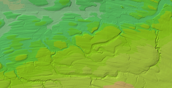
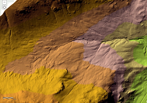
A LiDAR image of the country around Wigton showing an ice-moulded drumlin topography created when mainly Lake District ice reversed the flow of Scottish ice and displaced it from the Vale of Eden. Geomatics LiDAR Composite WMS Feed Map, Environment Agency, Open Government Data Licence.
The Cumbrian lowlands are largely blanketed by glacial deposits as evidenced by the common occurrence of drumlin fields including several classic examples. During its retreat the British-Irish Ice Sheet left many ice-margin features such as moraines and glacial meltwater channels. The BRITICE project has documented the full gamut of depositional elements and many of the British Geological Survey drift maps have useful summary maps of ice movement indicators and/or Quaternary depositional domains. Ice marginal lakes were extensive at times along the west coast as the major ice sheet in the Irish Sea Basin blocked meltwater from the waning Lake District ice. Glaciofluvial complexes have left a record of lacustrine and fluvial deposits some of which preserve valuable information on small segments of the glacial history and in places they were deformed by readvances of Irish Sea ice. During the retreat of the BIIS, Scottish and Lake District ice became more discrete bodies and phases of Scottish ice readvance blocked drainage forming glacial lakes around Carlisle and in the Vale of Eden which is characterized by abundant meltwater channels. Readvances were also responsible for deforming earlier glacigenic deposits as is well seen on the St Bees foreshore. Meltwater is a powerful agent for transporting sediment which is in abundant supply in a glacial environment. Esker, kames, and sandars, are all glacifluvial in origin depositing sands and gravels. These features are formed on, in, or below, the ice or in front as outwash.
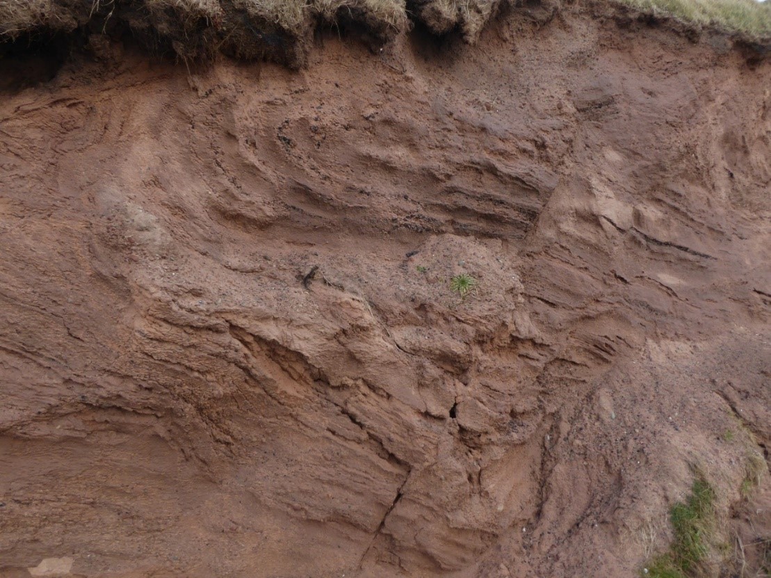
Deformed glacigenic sediment south of the Main Beach at St Bees. A critical wedge model, involving all the glacigenic sediments above the rockhead and the ice sheet, has successfully accounted for the observed extensional and contractional/thrust faults plus their associated folds.
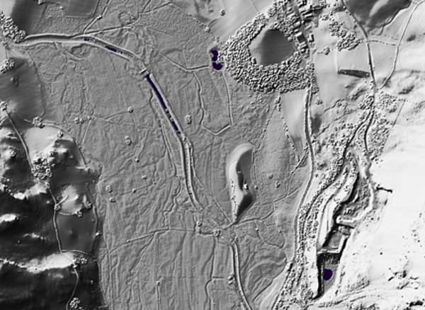
A remnant of an esker in St John’s in the Vale, south of Lowthwaite Farm and just to the west of Bramcrag Quarry. Eskers are formed by meltwater but are susceptible to erosion by meltwater and are rare in the Lake District. LiDAR image from https://houseprices.io/lab/lidar/map.
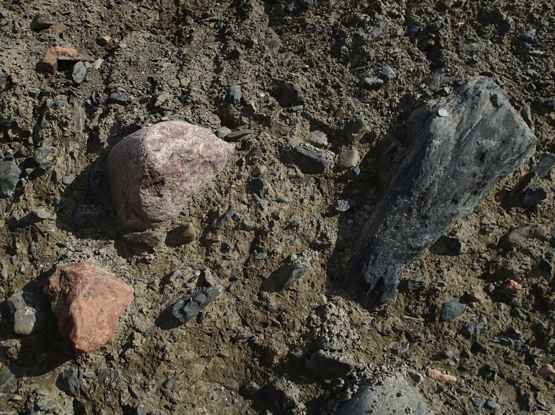
Glacial till in the Westmorland Borrowdale valley showing local provenance with clasts of Shap granite, the brick red quartz feldspar porphyry of the Shap Swarm dykes, and Borrowdale Volcanic Group andesite. Once called boulder clay the preferred lithological term is diamicton.
Ice free by 15 ka BP, the Lake District was under periglacial conditions for around two thousand years in the Windermere Interstadial before an abrupt return to a severely cold state in the Loch Lomond Stadial [Younger Dryas]. This cold phase is dated between 12.9 and 11.7 ka BP and has been attributed to a weakening or failure of the Gulf Stream [Atlantic meridional overturning circulation]. To show how dependent we are on this ocean current, the southern hemisphere continued on a warming trend during the Younger Dryas as glaciers were re-established on the Lakeland Fells. Around the year 2000 there was a dramatic upheaval in the conceptual framework that research provided about our understanding of this short-lived event. Previously it was believed to be a small-scale alpine-style glaciation with ice occupancy of cirques and limited ice flow down glacial troughs. Now, much evidence has been gathered to support the existence of extensive plateau ice fields which makes a lot more sense in terms of the climatic data for the period. Despite many publications on the new data it was still possible to see in 2019 documents that had not been updated saying “in northern England it [the YD] was limited to small corrie glaciers in the Lake District”. The largest plateau ice field was around High Raise but others occupied the Grey Knott-Brandreth plateau, Kirk Fell, and Dale Head. Ice thickness was at its maximum between 100 and 150 metres and the largest ice fields were between 10 to 15 km in north/south and east/west extents though of irregular shape. Outlet glaciers drained the ice fields and they have left quite a bit of evidence in terms of ice margin moraines and meltwater channels that trend obliquely down valley sides. Much of the hummocky terrain in the Lake District is of this age. YD landforms are typically fresher in appearance than features created in earlier glaciations though this discriminant does not always work. Soil profiles over YD landforms are less developed than over the main Devensian structures but the best age determinant is cosmogenic isotope dating of surface-exposure time though this technique is not without its problems.
LiDAR image of Little Gatesgarthdale between Honister Hause and Seatoller showing the Younger Dryas moraines that trend obliquely down the valley sides. These landforms mark ice margins created as the outlet glaciers from the plateau ice fields retreated. Geomatics LiDAR Composite WMS Feed Map, Environment Agency, Open Government Data Licence.
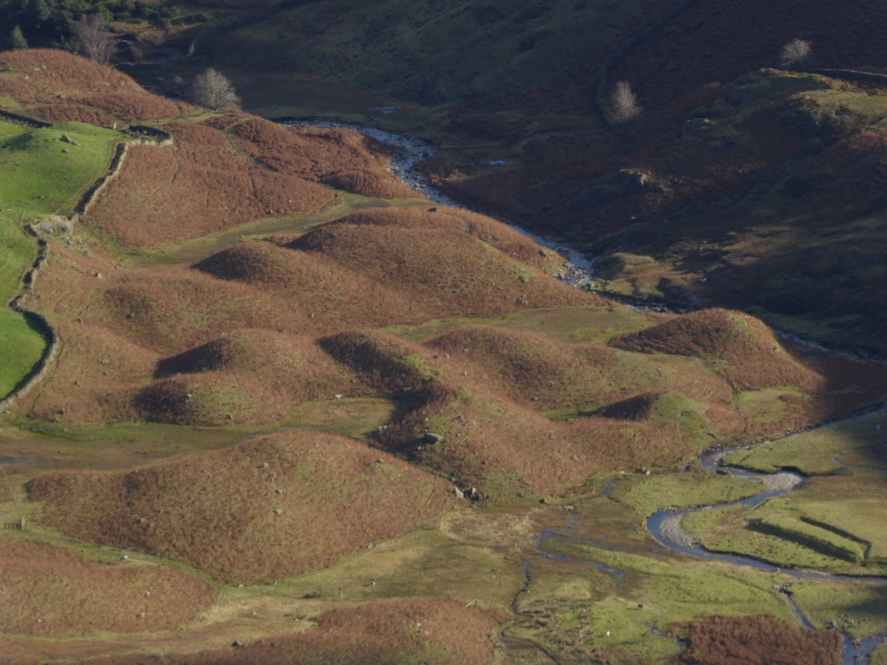
Hummocky moraine at Widdygill Foot, Little Langdale. These features are share many characteristics with Younger Dryas deposits elsewhere in the Lake District but they are at a low altitude and their probable accumulation site was south facing suggesting an older age. It would have taken abundant windblown snow to form a glacier in this area in the YD.
A clear consequence of excavating the glacial toughs was the formation of around seventy rock-slope failures. Large masses of rock have slipped out of position on the valley sides. Many have not travelled far before they stabilized but some have moved so far that they have left a cavity behind. It appears that by forming a steep sided trough the stresses within the rock mass have been perturbed sufficiently to cause failure. These features are defined by arcuate fractures and headwall scarps; Hackney Holes, on the flanks of Robinson overlooking Buttermere, are an impressive example of the latter. The great majority are post-Last Glacial Maximum though some appear to have been modified by the passage of ice and hence are earlier.
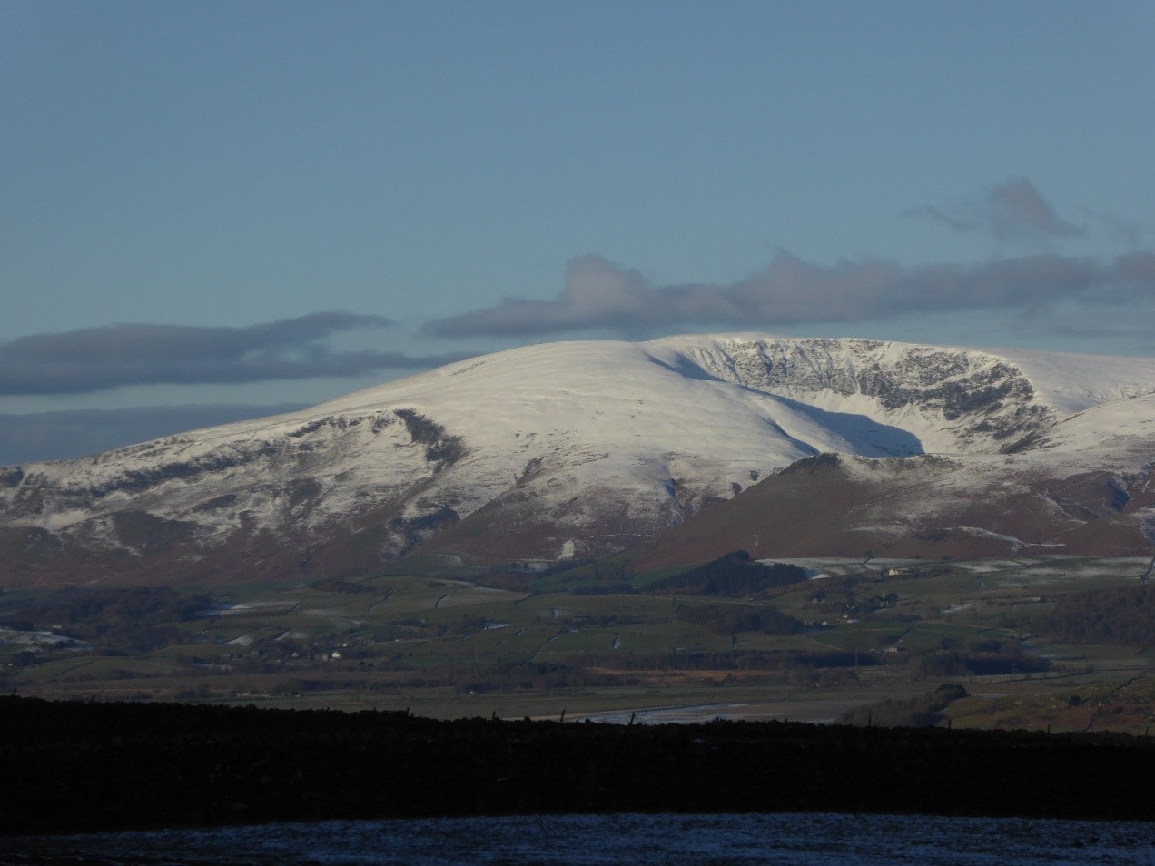
The Cotley rock-slope failure to the left of Black Combe summit and Blackcombe Screes [where some bedrock structure is picked out in the Skiddaw Group]. The view is across the Duddon Valley from Kirkby Moor.
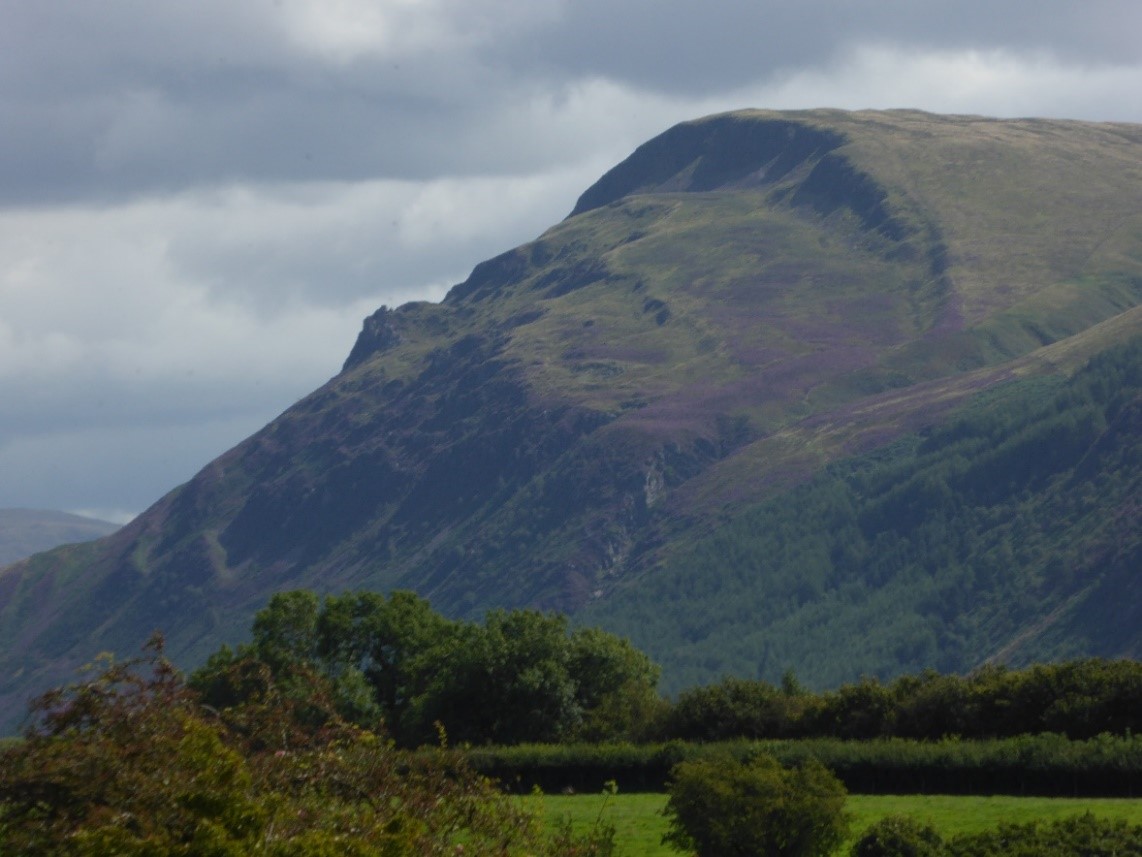
Revelin Crag rock-slope failure above Ennerdale Water. The scarp at the top of the landslide is 15-20 m high giving an indication of how far the rock mass moved before it was arrested.
At the end of the Loch Lomond Stadial temperatures rose at a dramatic rate of around one degree Celsius per decade to mark the beginning of the Holocene. In about one hundred years summer temperatures had increased by 8oC because the Gulf Stream had returned. Key geological parameters during the Holocene were rising global sea level, isostatic rebound after removal of the ice load, and the return of vegetation to stabilize the great piles of loose glacial debris. The interplay between the land and sea level rising defines relative sea level change and has left its mark on the landscape. Global ice volumes had been decreasing since about 20 ka BP as the continental ice sheets retreated and this was matched by eustatic sea level increase. Isostatic rebound depends upon solid-state flow in the asthenosphere which can be calculated fairly straightforwardly. Averaged over the Holocene relative sea level change in Cumbria varies from 1.0 mm per year in the north to 0.5 in the south. Because the isostatic component is decaying this balance has changed and the Morecambe Bay data show how this is reflected at different times in the Holocene starting 20 m below current levels, going above at about 6 ka BP and then gradually converging on the current level. Human activity first leaves its mark at about 5.5 ka BP when forests began to be cleared for agriculture over a sufficient area to be apparent in pollen data. Currently we are officially living in the Meghalayan Age of the Holocene Epoch but the search is on for a geological signal that will define the point at which humans profoundly started to leave their mark on the geological record – the beginning of the Anthropocene with a preferred start date in the mid-20th Century. According to the International Union of Geological Sciences phenomena associated with the Anthropocene include: an order-of-magnitude increase in erosion and sediment transport associated with urbanization and agriculture; marked and abrupt anthropogenic perturbations of the cycles of elements such as carbon, nitrogen, phosphorus, and various metals, together with new chemical compounds; environmental changes generated by these perturbations, including global warming, sea-level rise, ocean acidification, and spreading oceanic ‘dead zones’; rapid changes in the biosphere both on land and in the sea, as a result of habitat loss, predation, explosion of domestic animal populations and species invasions; and the proliferation and global dispersion of many new ‘minerals’ and ‘rocks’ including concrete, fly ash and plastics, and the myriad ‘technofossils’, produced from these and other materials. The search is on for the “Golden Spike” which will define the end of the Holocene.