
THE CUMBRIAN RING

THE CUMBRIAN RING
To railway aficionados the Cumbrian Ring is the ring of steel railway lines around the Cumbrian coast together with the Settle-Carlisle and Bentham lines to complete the circuit at Carnforth. In a geological context it is the encircling post-Acadian rocks around the Lower Palaeozoic core of the Lake District. Because this account is divided sections defined by unconformities not by geological periods this section starts within the Devonian but it also involves a bit of a fudge because some Devonian rocks have strayed away from the ring concept. During the Devonian the Lake District was in a subtropical warm to hot, semi-arid, climatic belt and patchy deposits were formed in terrestrial environments. This is the Old Red Sandstone of the early stratigraphers. After the Acadian Orogeny deep erosion produced a continental peneplain by removing as much as a ten kilometre thickness of rock which was mainly transported southwards. A major casualty of this erosion was the Early Devonian pre-Acadian fluviatile sequence that provided the cover required to create the metamorphic conditions for the slate belt. There are a couple of remnants of the post-Acadian red bed deposits around Great and Little Mell Fell. These are conglomerates up to 1,500 m thick which have sampled all of the older rocks and a key observation is that the clasts of slaty material have cleavage attitudes with random orientations showing that the deposits post-date the Acadian Orogeny. The Mell Fell Conglomerate Formation could have formed in a small rift valley but the most likely setting was a valley eroded along the Causey Pike Fault and environments were alluvial fans to braided rivers.
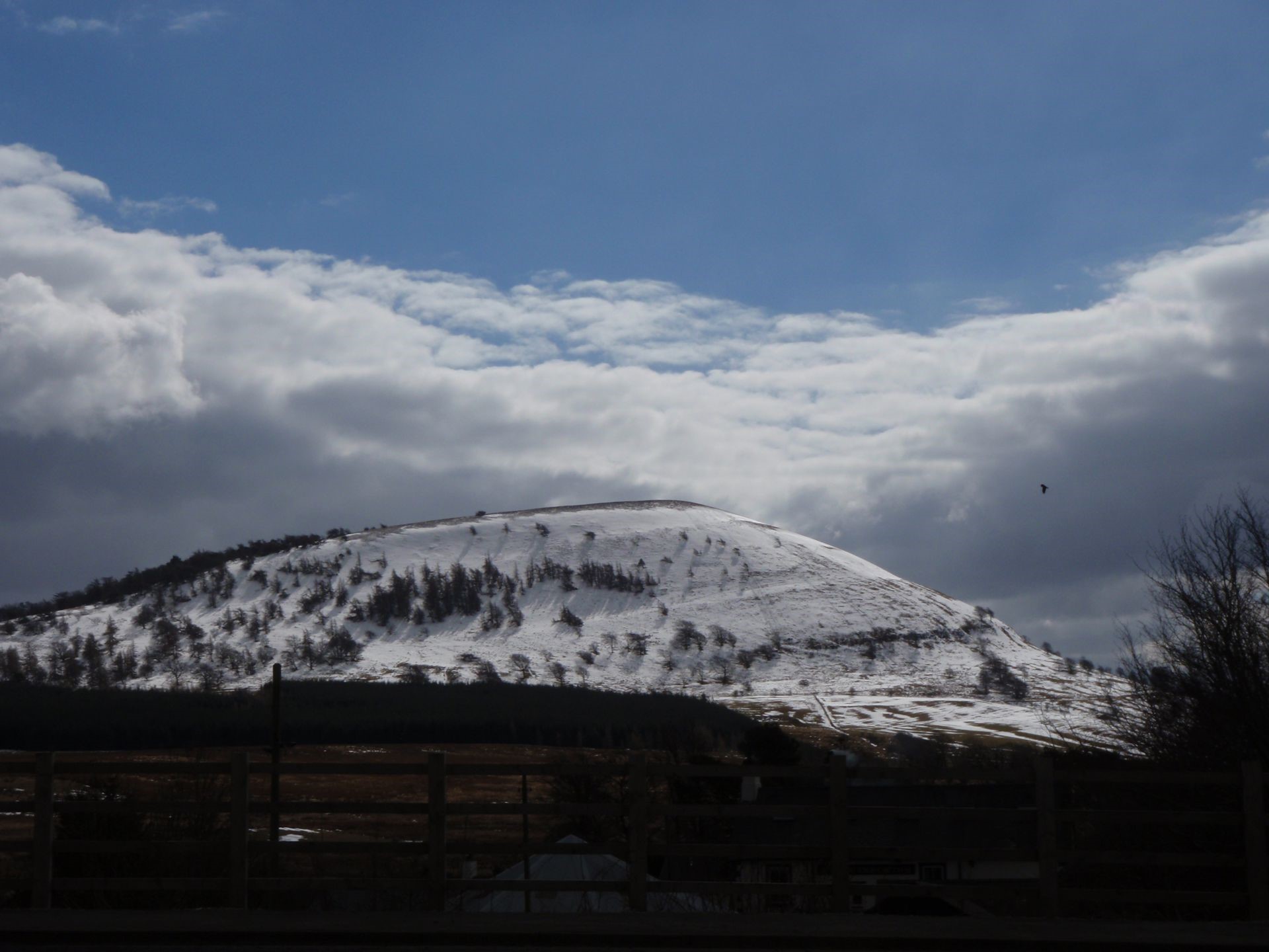
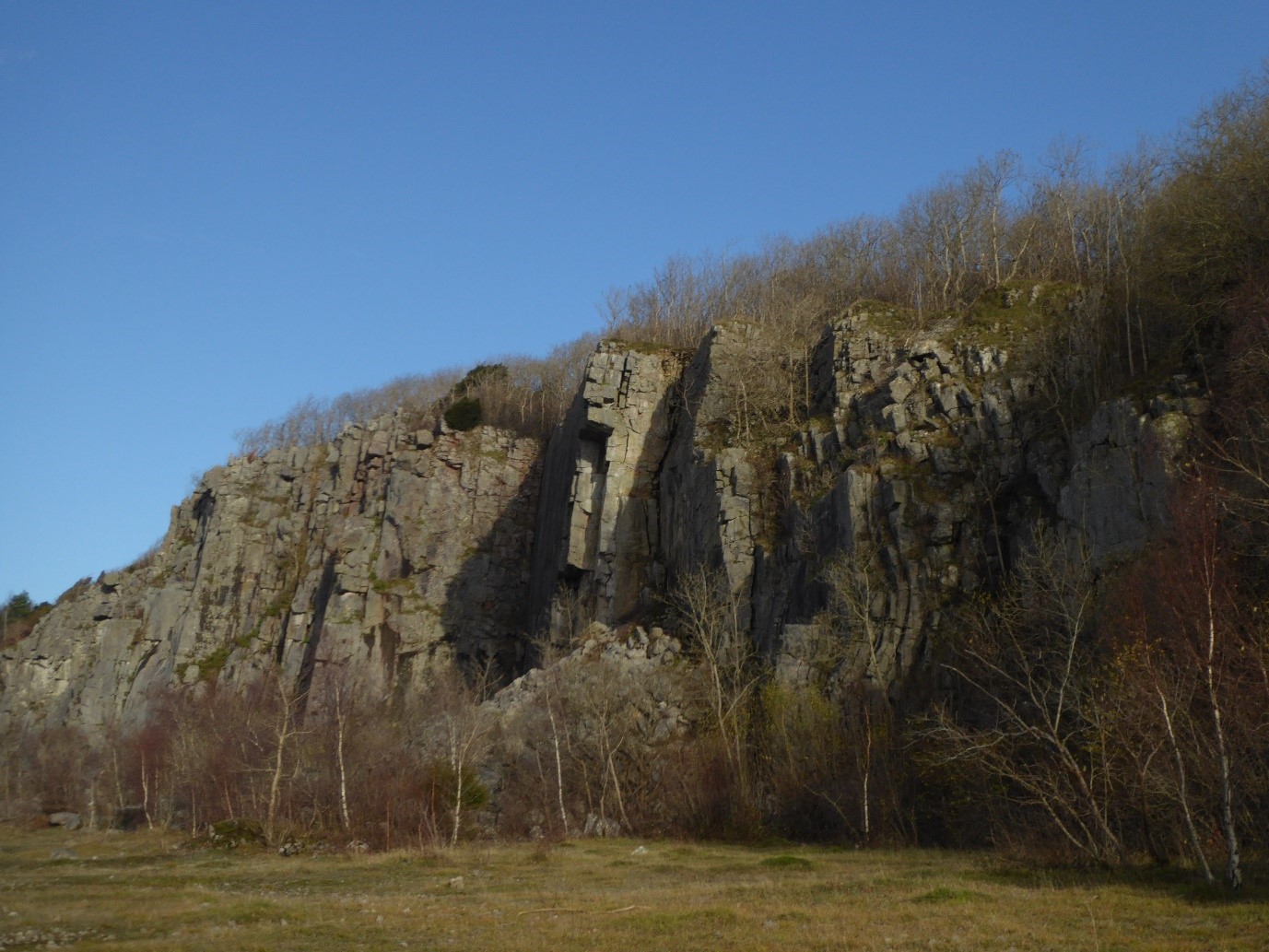
Mell Fell Conglomerate Formation on Great Mell Fell viewed looking south. The light dusting of snow highlights the very subtly-defined bedding which dips gently to the east. Very-low bedding dips are an almost universal characteristic of deposits formed after the Acadian Orogeny.
Whilst Carboniferous rocks are very extensive in northern England they have a very minor presence in the Lake District National Park. Even widening the area of interest to Cumbria, the Carboniferous strata, though economically significant, are still not major players in terms of area. The lithospheric stretching that was to dominate the early part of the Carboniferous started in the latest Devonian and was responsible for thin local red-bed conglomeratic, sandstone, and mudstone, deposits that pass upwards into thick Carboniferous limestone sequences around much of the Cumbrian Ring. At Shap Wells an example of this red bed sequence has, as clasts, fragments of the pink feldspar megacrysts from the Shap Pluton giving the younger stratigraphic limit to the age of intrusion. The Shap Wells Conglomerate Formation is latest Devonian in age and is overlain by the Ravenstonedale Group probably with a small time gap between the two units. 1:50,000 and smaller scale maps show the Shap Wells being overlapped by the Ravenstonedale indicating that the depositional basin was being progressively enlarged during the transition from continental conditions to marginal marine as seen in the Pinksey Gill Formation, the oldest part of the Ravenstonedale. Overstepping continues into the Marsett Formation which is the first regionally extensive Carboniferous unit though depositional conditions were a mixture of marginal marine and non-marine in the form of alluvial fans and fluvial. Within the Ravenstonedale, in the north of the Lake District, the Cockermouth Volcanic Formation extends over 13 km comprising six olivine basalt lava flows with a total thickness of 100 m.
Devonian age red beds at the base of the Carboniferous succession, Shap Wells. Glacial deposits overlie the bedrock and blanket much of the area. This locality is notable for the presence in the conglomerate of megacryst feldspars weathered out of the Shap Pluton and transported here by streams.
Above the Ravenstonedale Group Carboniferous stratigraphic sequences around the Cumbrian Ring are markedly different and two, almost diametrically opposite, end-members will be used to illustrate the range of deposits. In the south, the succession between Cartmel and Arnside has a fairly-complete early Carboniferous sequence dominated by limestones. In contrast west Cumbria has a patchy early Carboniferous record but has significant later Carboniferous siliciclastics including coal measures which are not present in the south. When the Devonian peneplained surface was involved in extensional tectonics, the Lake District acted as a tilt block dipping to the south setting up a ramp depositional environment. Ramps have an even fairly-regular slope in contrast to a typical shelf environment which is essentially flat until the shelf break into the continental rise. A northwards progressing transgression initiated limestone deposition over south Cumbrian ramp which was only eliminated towards the end of this carbonate episode. The current belt of Carboniferous rocks in south Cumbria straddle the strike of the ramp so there is limited information about different environments at any one time but reasonable inferences can be made about conditions to the north and south.
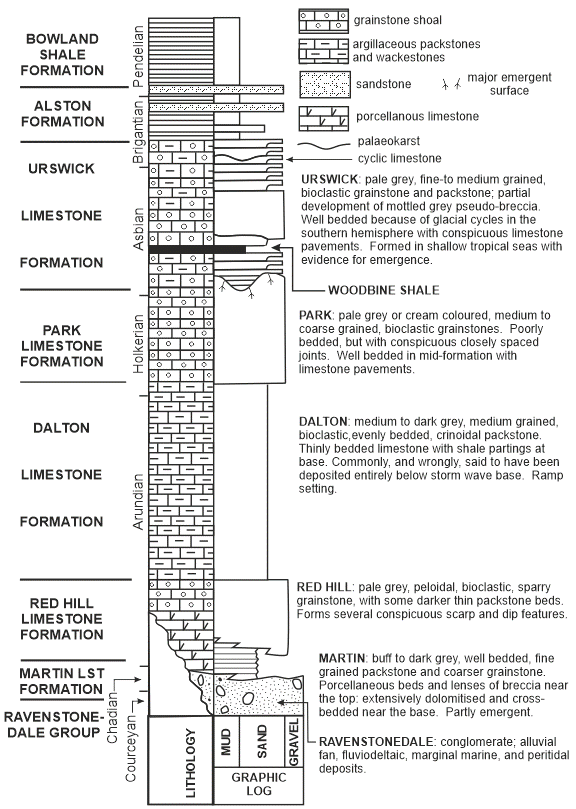
A summary of the Carboniferous succession in the south Cumbria, Furness, and Cartmel district based on Horbury & Qing 2004 ‘Pseudobreccias’ revealed as calcrete mottling and bioturbation in the Late Dinantian of the southern Lake District, UK. Sedimentology, vol. 51, pp. 19-38.
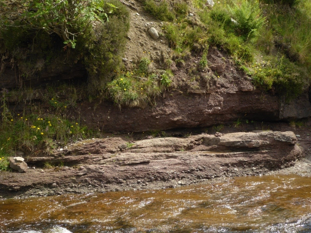
The oldest carbonate unit in south Cumbria, the Martin Limestone Formation, is a variably dolomitized mainly carbonate mudrock with cross-bedded grainstones. It is interpreted to have formed in near-shore environments such as barrier beach complexes, tidal flats, and restricted lagoons. As this stage the marine transgression would not have penetrated much further over the Lake District Block which would have been largely emergent. The next unit, the Red Hill Limestone Formation, is interpreted to have been wholly subtidal but deposited in very shallow water of only a few metres depth. Lithologically it is a coarse-grained, structureless, bioclastic and peloidal grainstone formed in an inner ramp to mid ramp setting which means the coastal complex, equivalent to the Martin Limestone conditions, was a little further north. In each case where deposits are inferred north of the present-day belt, they were eroded during the Variscan Orogeny. Following the Red Hill, the Dalton Limestone Formation is an argillaceous packstone with shale partings. It was formed in deeper water in a mid to outer ramp setting though estimates of water depth vary. Published information suggests for the middle of the formation depths were in excess of 100 m but extensive evidence for storms influencing sedimentation indicate a somewhat lower depth. In the upper part of the formation dolomitization suggests a trend towards lessening water depth. It has been calculated that the shoreline at the time of mid-Dalton deposition was around Keswick and that there was little or no land over the Lake District. A corollary of this interpretation is that slope facies were just to the south of present-day Cumbria during much of Dalton deposition; the transgression required to establish this pattern started with a rifting event in the early Arundian.
Dalton Limestone Formation, north of New Barns Bay, Arnside foreshore. Pronounced lenticularity of beds is a product of storm sedimentation. Tablet 21.5 x 13.5 cm for scale.
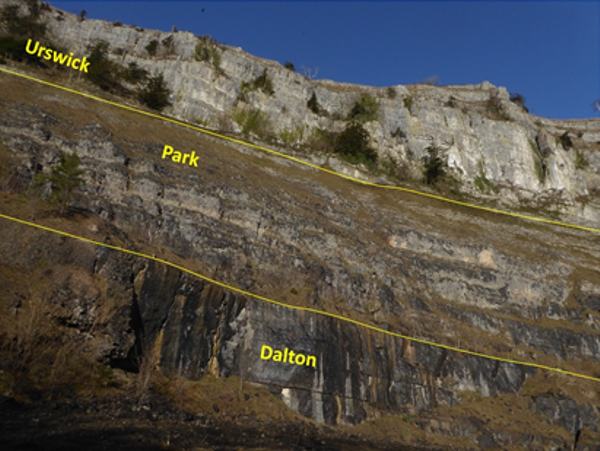
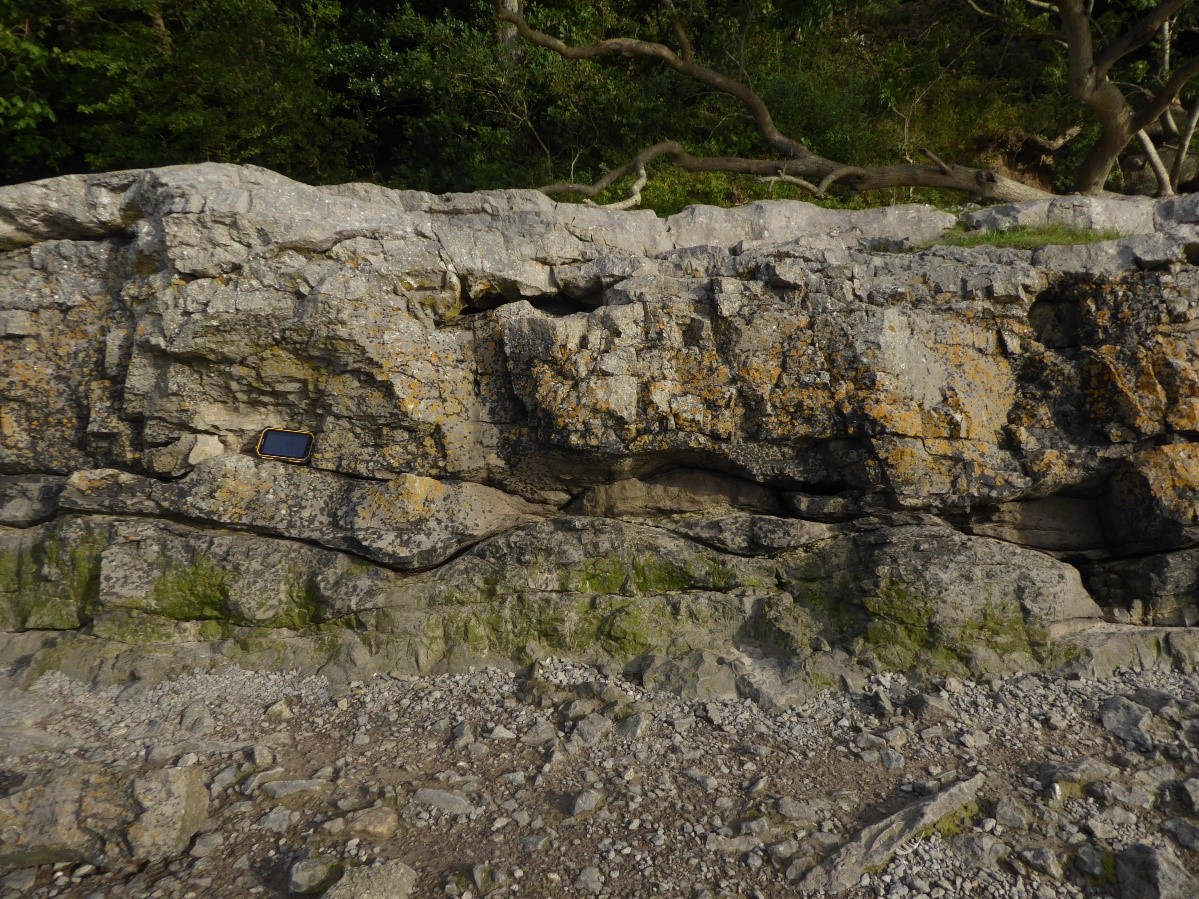
Good exposures of the Dalton, Park, and Urswick, formations on White Scar, Whitbarrow. Cliff face is approximately 70 metres high.
Next in the sequence is the Park Limestone Formation which is a pale, structureless, apparently unbedded in many locations, bioclastic and peloidal grainstone where the lack of defined layering is a product of bioturbation. It is interpreted as a shallow-water deposit formed in water depths of around 10-30 m in a setting controlled by slow subsidence after a phase of rifting. The last of the predominantly carbonate units is the Urswick Limestone Formation whose base is defined by a palaeokarst surface at the top of the Park. In terms of rock types it is a pale grey, fine to medium grained, bioclastic wackestone to packstone. For about half of the time taken to deposit the Urswick, south Cumbria was emergent and for the other half very shallow seas occupied the area; conditions frequently cycled between these two states. During periods of emergence the whole of the region north of Carnforth was flat-lying and just above sea level covered by extensive vegetation with at times substantial trees several metres in height. The sedimentary cycles are bounded by emergent surfaces [palaeokarst] covered with thin veneers of shale mainly derived from fine volcanic dust blown in on the wind. Clearly it would take a long time to accumulate even the centimetric layers of shale by this mechanism and it has been estimated that they represent half to two-thirds of the time needed for a cycle. Given that the Urswick has between 30 to 40 cycles and took between 3.5 to 5.5 myrs to form, each cycle was between 100,000 to 120,000 years which means the shale layers typically represent 50,000 to 80,000 years. The Urswick Limestone has most of the limestone pavements in the region developed on the hard upper portions of the cyclic sequence. As the water depth became very shallow, short-lived emergence allowed rainwater to percolate into the carbonate sediment which then was drawn upwards in the semi-arid environment. This process precipitated a calcareous cement and the extreme example is the final emergent surface where vegetation was established. Ancient palaeokarst thus became modern limestone pavements. Following the predominantly limestone deposits the region entered a phase of cycling between marine and deltaic environments in the Yoredale Group. This unit in south Cumbria is only 180 m thick and is very poorly exposed, the best exposures being on the Holker Estate in the basal Alston Formation. Limestone, sandstone, siltstone, and shale, are the main rock types notable amongst which is a very attractive crinoidal limestone seen as building stone in Cartmel and Holker. Cartmel Priory was mainly constructed from sandstone horizons in the Alston Formation.
Palaeo-pits approximately a metre in diameter formed when trees were established on an emergent surface, Urswick Limestone Formation, Trowbarrow Quarry. The layer here is sub-vertical in the Silverdale Disturbance to expose a bedding plane view.
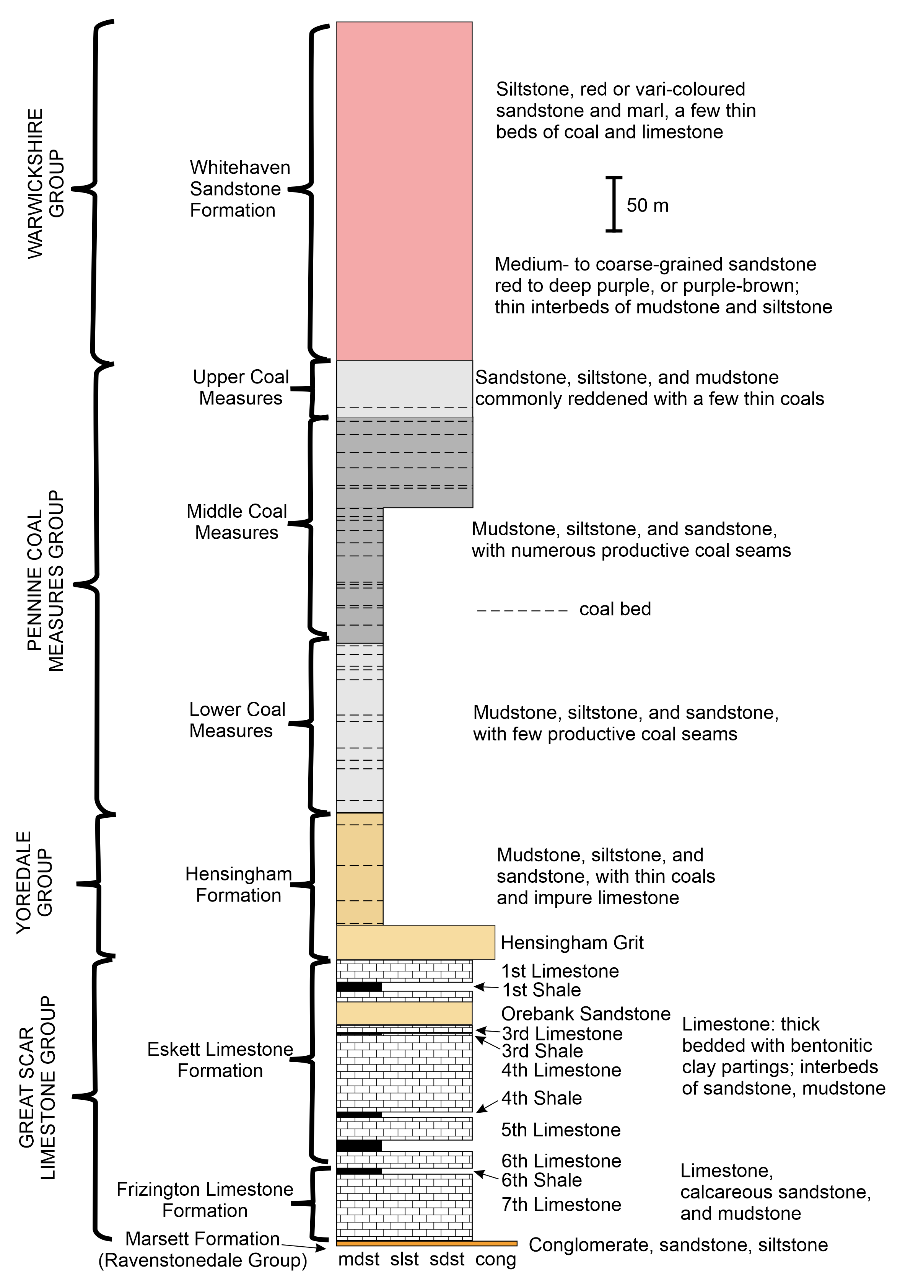
Lithostratigraphy and lithologies for the northwestern Cumbrian Carboniferous succession. Data taken from the British Geological Survey Whitehaven Sheet 28 1:50,000 Series [Keyworth, Nottingham].
Carboniferous stratigraphic columns around the Cumbrian Ring display quite a wide range of sequences. Northwest Cumbria has been chosen to highlight the area where there is the greatest departure from the carbonate-dominated south though it does start with the mainly limestone Great Scar Limestone Group but shale and sandstone are more prominent in its Frizington and Eskett formations. As in the south the limestones start with a peritidal unit and then conditions alternate between shallow marine and periodic emergence in multiple transgression-regression cyclothems. Above the Great Scar the Yoredale Group, represented by the Hensingham Formation, is only one tenth of the thickness seen elsewhere around Cumbria. Depositionally it was a cyclical sequence of marine and deltaic environments producing repetitive stacks of mudstone, laminated siltstone, sandstone, thin limestone, and thin coals. A reduction in the impact of marine conditions introduced the Pennine Coal Measures Group which covered most of northern England in a continuous sedimentary basin. At first this was a marine-influenced delta plain with a moderate number of marine incursions most notably producing sulphur-rich coals and enhanced iron-content in the siliciclastic deposits. Throughout the coal measures cyclothems on a ten metre scale created packets of marine shale, non-marine shale, sandstone, rootlet bed [seatearth/palaeosol], and coal seam. Coal was formed in dense tropical forests in delta top settings needing to be established for thousands of years to create a workable seam. Approximately half way through the Lower Coal Measures the marine influence became minimal and in Middle Coal Measures times most of the productive coal seams were deposited. For most of the Coal Measures mudstone is the dominant lithology but higher up sandstones take over as the main rock type. Compared to coalfields in Lancashire the northwest Cumbrian coal measures are a condensed sequence being less than a quarter of the thickness typical elsewhere. Offshore the thickness of productive coal measures increases and a gentle regional dip, rarely more than ten degrees towards the Irish Sea, was followed up to five kilometres offshore by mining under Permian cover.
Eventually the effects of the rising Variscan mountains to the south began to influence the Lake District. Sediment from this developing topography was transported north by river systems and led to the deposition of the Warwickshire Group. This is characterized by red-bed strata of alluvial facies where the reddening is attributed to early diagenetic oxidation either at, or soon after, deposition. The Whitehaven Formation is considered to be fluvial of fluvio-lacustrine in nature being mainly sandstone with minor grey mudstone, thin coals, lacustrine limestone, and pedogenic limestone [caliche and calcrete]. There is the possibility that in some areas close to the unconformity with the overlying Permian the early reddening might be enhanced by post-Carboniferous oxidation.
VARISCAN OROGENY
Despite the enormity of the impact of the Variscan Orogeny globally it was a mild deformation event in the northwest of England. On the World stage this orogeny created the vast supercontinent of Pangea placing England near the centre of this continental assembly that stretched from pole to pole. Ocean basins to the south of England were closed having a major effect on Devon and Cornwall but we were in a far-field setting with only highly localized intense deformation mainly along pre-existing fundamental structures. A measure of the impact of the Variscan in the Lake District region is the typical angular discordance between bedding in the Carboniferous and Permian rocks which is normally just a few degrees. This perhaps underplays the significance of the event because it led to the Carboniferous deposits being stripped off the centre of the Lake District and even low angles of discordance when projected over kilometres on the ground can markedly modify map patterns as can be seen near Kirkby Stephen on British Geological Survey, GeoIndex Onshore regional maps. These are classic signs of basin inversion when what was a depocenter for Carboniferous sediments underwent a reversal to become an uplifted region undergoing erosion during the Variscan Orogeny. Straddling the Carboniferous/Permian boundary a duration of about 15 myr has been estimated for this deformational and magmatic event.
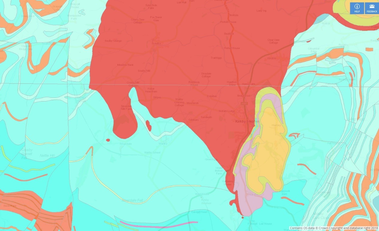
The angular unconformity between Carboniferous and Permian rocks is clearly visible in the Kirkby Stephen area even though there is only a few degrees difference in attitude. The unconformity truncates layer boundaries in the Carboniferous succession. The east-west extent of the map is approximately 12 km; British Geological Survey, GeoIndex Onshore.
Over the years there has been much debate about the orientation of the stress field responsible for the Variscan folding and faulting with there being evidence for both east-west and north-south compression. There has been a tendency for authors to support one or the other of these causes for the deformation but a resolution of the conflict is developing. Much data points to north-south compression being the first deformation event followed by east-west compression. Perhaps surprisingly the latter compression was generated by a combination of strike-slip and extension. A very broad region, larger than northern England, with boundaries trending ENE-WSW, was undergoing dextral strike-slip whilst the zone margins were moving apart – transtension. This combination of displacement sets up approximately east-west compression. The first north-south compression event reactivated the fundamental basement structures that define the major blocks such as the Lake District, Alston, and Askrigg. Because of the variable strike of these basement structures the strike-slip senses varied. Along the NNE trending Dent line it was sinistral whilst on the NW/SE Craven Faults it was dextral and both were transpressional. Both of these belts are around a kilometre wide and beyond the confines of these shear zones the structural effects of the Variscan are minimal especially over the granite-cored blocks. A good example of the variable impact of the Variscan is found straddling the Cumbria/Lancashire border between Arnside and Silverdale. In a belt trending north south from Storth to Leighton Moss there is a zone a few hundred metres wide of sub-vertical to overturned Carboniferous limestones. This is the Silverdale Disturbance which is localized on an older basement fracture that was reactivated in the Variscan. Away from these zones of complexity deformation is weak except for very localized complications. A couple of kilometres from the Silverdale Disturbance on Arnside Point there is a gentle, rounded, synclinal fold with limb dips of about 20o which are higher than the average for Carboniferous rocks in the Cumbrian Ring. Close by near the Arnside Coastguard Station there is an example of localized complexity where a zone, just a few tens of metres across, developed in a predominantly strike slip mode but with an element of compression across the zone. This resulted in a faulted and folded belt with many of the folds being genetically dependent on faulting.
Overturned Urswick limestone in Trowbarrow Quarry, Silverdale Disturbance. The view is towards the north along the line of the belt of steeply dipping rocks.
An interpretation of part of the localized zone of complexity in the Dalton Formation near the Coastguard Station at Arnside. Here a fault-bounded zone has undergone strike-slip movement whilst at the same time the fault boundaries have moved together to create a compressive component. Abundant striations demonstrate the overall strike-slip motion but contractional faults prove the compressive element and folds genetically related to the thrusts are prominent.
Magmatism was a significant part of the Variscan Orogeny in northern England though of a very different composition to that associated with the Acadian. The Whin Sill Swarm of doleritic sills and dykes covers a large area of northern England. The main element, the Whin Sill, is typically 30 m thick though in places it is 90 m; it is the eponymous sill giving its name to all igneous [and sedimentary] intrusions that parallel the host bedding. Locally it is transgressive cutting across layers but for the most part it is concordant. Radiometric dating gives an age of 297.4 Ma for the Whin swarm [very earliest Permian] and an interesting connection has been made between the famous Pb-Zn mineralization in the North Pennines and the sill. Traditionally this mineralization event was thought to have been formed by hydrothermal fluids circulating in, and leaching minerals from, the Carboniferous sedimentary host rocks. The driver for the fluid flow was believed to be the Weardale Granite which, even though it is Acadian in age, was thought to have had sufficient heat production from isotope decay to create a chimney effect. However, studies of Rhenium and Osmium isotopes in the metalliferous minerals have shown that they were sourced in the mantle thus overturning decades of long-held beliefs. This information strongly links the magmatism and mineralization to the same overall tectonic event and dating of the vein assemblages gives an age only slightly younger than the Whin Sill. Scenically the Whin Sill is responsible for our own Grand Canyon, High Cup Nick; the ramparts that define this valley are cliffs in the Whin Sill.
PERMO-TRIAS & LIAS
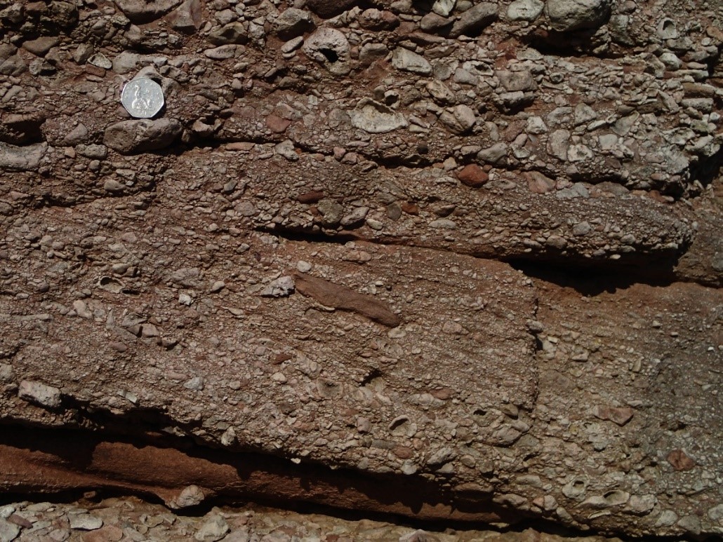
Permian continental red beds with cross bedding, Appleby Group Brockram, Roughholme Point, Cark. Most clasts are Carboniferous limestone. Brockram was formed in the mid-Permian by flash floods reworking coarse deposits created by the degradation of rift valley fault escarpments.
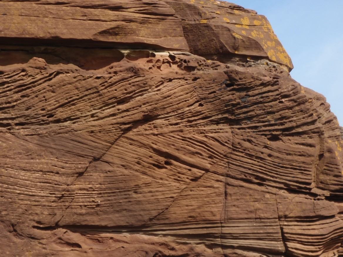
These are the last bedrock units to be deposited in the Lake District before a long gap in the rock record until Quaternary glacial activity deposited unconsolidated material. Britain was now near the centre of a massive supercontinent that extended from Pole to Pole. In the early Permian the Lake District was about 10o N and drifted to 30o N by the early Triassic. The Variscan Orogeny had created a major mountain range to the south and, because Britain was in the rain shadow of this mountain chain, arid conditions prevailed. It is a classic red-bed succession largely isolated from marine influence when desert conditions typified this time interval until late in the Triassic. Shallow, evaporitic, tropical seas made inroads into the region from time to time but sedimentation mainly took place in desert, fluvial plain, ephemeral lake, and mudflat, settings. Throughout the early Permian, erosion actively reduced the moderate topography created by the basin inversion caused by compression in the Variscan. In the mid-Permian, extensional tectonics reactivated major structures in the basement most of which were the fundamental lineaments defining the blocks of northern England. A new topography was now established with the blocks [Lake District, Alston, Askrigg] as upland areas supplying detritus to the Permian basins which were bounded by rift-valley style fault scarps. Basin-margin alluvial-fan breccias [Brockram] were the first deposits in wedge-shaped bodies that tapered off away from the rift valley margins. Subaerial sheetfloods, debris flows, and braided rivers, operated on coalescing alluvial fans. In the Vale of Eden, away from the fault scarps, desert basins filled with sand transported by aeolian dunes with sets up to five metres in height. During this period there was a persistent ESE palaeowind. These wind-blown sands largely overly the Brockram but they also interfinger. Formally both the Brockram, and the predominant aeolian sandstones, are included in the Penrith Sandstone Formation which is locally close to a kilometre in thickness and which is part of the Appleby Group.
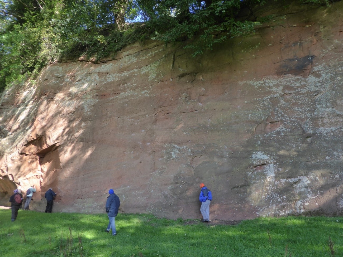
Dune cross-beds in the Penrith Sandstone Formation, Bongate Scar, Appleby. The cliff is approximately ten metres high.
Continued rifting brought about a major change in the depositional regime as an inland sea was now able to encroach upon the rift valley system whilst maintaining a connection with the open ocean far to the north through a narrow passage between Greenland and Scandinavia. Known as the Bakevellia Sea it was never more than a very shallow evaporitic body of water over the onshore areas of Cumbria and this led to a wide range of depositional conditions as the sea waxed and waned; the whole assemblage is the Eden Shales Formation. During regressions vast flat areas were exposed where mudstones, sandstones, and siltstones, were deposited by sheet floods, aeolian processes, or in lakes. Marginal marine areas were broad supratidal plains [sabkhas] characterized by extensive diagenetic evaporite mineral-growth in the shallow subsurface. In the Eden Valley evaporite minerals have been exploited and detailed information about the sedimentary conditions has been collected. Three periods of evaporite deposition have been identified intercalated with grey shales made grey by a high organic content which indicates that the source area was dominated by a conifer flora. On the west coast of Cumbria the equivalent units are the St Bees Evaporite Formation and the St Bees Shale Formation.
Just before the Permian-Triassic boundary a major river system reached northwest England having worked its way through the network of rift basins to the south and having risen in the Variscan mountains. This was an endorheic system as there was no outlet from the East Irish Sea Basin and it deposited the St Bees Sandstone Formation. At its base this formation includes a few metres transition zone from the shales below where there is interbedding of playa-lake mudrocks and sheet sandstones deposited from sheetfloods that blanketed a low-relief mudflat. Above this is the main sandstone body created by a sandy braided fluvial system with thick channelized sandstones. At the start of St Bees sandstone deposition, the Lake District Block was still a minor sediment source but it was very subdued and progressively the fluvial system extended over the Lake District. Though the region was entering the post-rift thermal-subsidence phase, variations in the thickness of the St Bees Sandstone show that some growth faulting was still occurring. The fluvial system was abruptly abandoned leading to a sharp contact with the overlying Calder Sandstone Formation which is 88% aeolian in origin. Within the Calder there are sporadic fluvial deposits and the unit is capped by a fluvial horizon which separates it from the Ormskirk Sandstone Formation which has an exclusively aeolian lower part and the unit is notable for being the gas reservoir in the East Irish Sea Basin. This unit marks the end of the rock record in the Vale of Eden and the onshore part of West Cumbria. Offshore and in the Carlisle Basin sedimentation continued for the rest of the Triassic and into the Jurassic. This was now firmly in the thermal sag phase of the rift sequence and gradually marine conditions were established in the late Triassic. There are very few exposures of the Carlisle Basin succession and many are of poor quality. Information about the basin is almost entirely dependent on boreholes and seismic reflection profiles.
Trough cross-bedding, with minor soft-sedimentary deformation, in the St Bees Sandstone Formation, St Bees Head. The set heights are typically 40 cm.
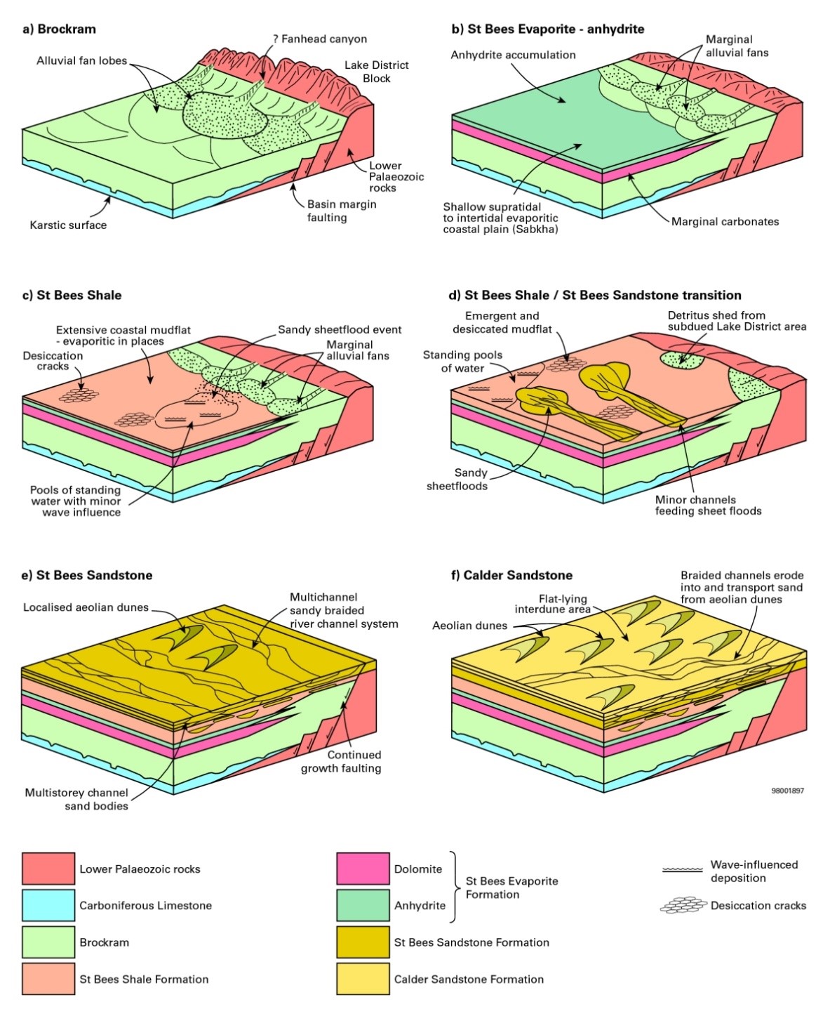
Cartoons illustrating the changes in depositional regimes through Permian and Triassic times in west Cumbria (after Akhurst et al., 1997. The geology of the west Cumbria district. BGS Memoir). Figure 56 in Stone, P, Millward, D, Young, B, Merritt, J W, Clarke, S M, McCormac, M, and Lawrence, D J D. 2010. British regional geology: Northern England. Fifth edition. Keyworth, Nottingham: British Geological Survey. Earthwise P916086.
Having outlined the geology of the post-Variscan rocks in Cumbria it is worth briefly mentioning the haematite deposits. Very few researchers dissent from the view that the iron in these deposits was derived from the Permo-Trias red-bed succession. Somewhere around 200 million tonnes of haematite was extracted mainly from ore-bodies in Carboniferous limestone but some workings in Lower Palaeozoic rocks contributed to the total. Probably the best estimate for the age of the mineralization comes from palaeomagnetic studies which places the event in the mid-Triassic. The best supported ore deposit model proposes that formation waters from the Permo-Triassic red beds in the centre of the Irish Sea Basin migrated to the basin margins to react with Carboniferous carbonate rocks to precipitate the iron. A key component in the model might be the ultimate origin of the fluids. It is suggested that they came from organic-rich coal measures which reacted with pore fluids in the red beds allowing them to strip iron from the coatings around grains in the red-bed strata.
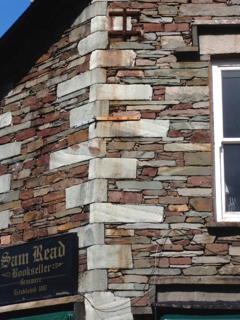
Building stone from Borrowdale Volcanic Group rocks in Grasmere with thin veneers of red iron oxides along joints. The quoins are free of this overprint and display stratification along cleavage planes and joints. Graded bedding in the quoins suggests a lacustrine origin.
Red is a fairly common component of names on Lake District maps [Red Screes +, Redacre Gill, Red Tarn +, Red Pike, Red Crags, Red Tarn Moss, Far Ruddy Beck, Near Ruddy Beck]. These place names draw attention to some of the areas reddened by iron-rich solutions that were introduced into the Lower Palaeozoic Inlier whilst the haematite deposits of places like Millom were being formed. Some of this mineralization in the basement was economic e.g. in Wasdale Granite at Nab Gill and in Skiddaw Group rocks at Keltonfell Top. Almost every Acadian fault, and earlier faults reactivated in this event, has had iron oxides introduced. Rocks are rarely penetrated by iron in these settings which typically is seen as thin veneers on fracture surfaces which adds an extra dimension to buildings made mainly from Borrowdale Volcanic Group rocks. Many screes are also notable for their red colour not just the named Red Screes. Such screes are sourced in fractured rock that have been reddened.
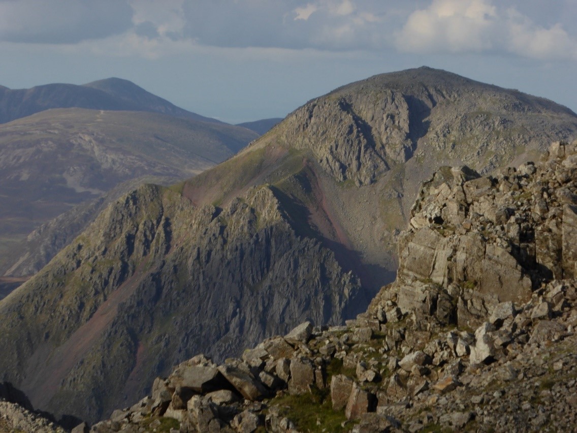
Red screes around Great Gable are sourced in fractured rock stained by iron oxides introduced in the mid-Triassic into the Borrowdale volcanic rocks at the same time as the haematite ore bodies were forming in places like Millom.