
LAKE DISTRICT EVOLUTION IN A PLATE TECTONIC CONTEXT

Adapted from: Stephenson, D., Bevins, R.E., Millward, D., Highton, A.J., Parsons, I., Stone, P. & Wadsworth, W.J. (1999) Caledonian Igneous Rocks of Great Britain, Geological Conservation Review Series, No. 17, Joint Nature Conservation Committee, Peterborough, 648 pp.
LAKE DISTRICT EVOLUTION IN A PLATE TECTONIC CONTEXT
English Lake District geology is the topic of this web site. Initially the target audience is anyone who has developed some familiarity with geology rather than folk starting from scratch; it’s too hard to deliver an introductory geology course as well as cover the evolution of a region like this which has had quite a history. Some background information will be provided on less familiar concepts so beginners are welcome to see how far they can get into what is presented here. Plate Tectonics has dominated Lake District evolution and this broad-brush overview will be used to set the scene for a more detailed examination of the rock groupings in the region.
People are drawn to the Lakes in their tens of millions each year by geology. Very few of these visitors articulate such a control on their motives for a visit but landscape is underpinned by the rocks. Variations in landscape reflect variation in rock types and their structures particularly fractures. Norman Nicholson the poet expressed these realities much better than me when he said “to look at the scenery of Cumberland and Westmorland without trying to understand the rock is like listening to poetry in an unknown language – you hear the beauty of the sounds, but you miss the meaning. For the meaning is the rock.” He emphasised the special nature of the Lake District when he observed “In no other part of England has the life and character of a district been so controlled by the nature of the rock and by the forces which acted upon it”.
For such a small area the Lake District has had a remarkably eventful history
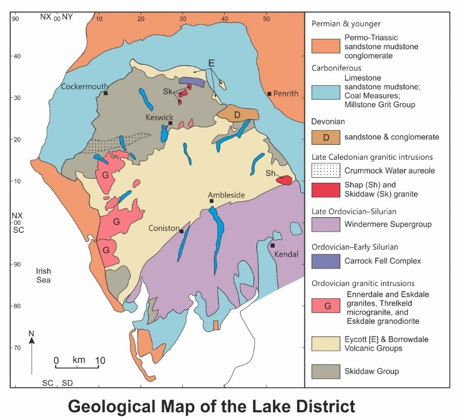
During their training geologists have “start an account of an area with the oldest rocks” drilled into them. Well to betray my heritage I wouldn’t start from here. If we went down the traditional route for the Lake District we would immediately come across a common situation in geology because there is no universal agreement about the age of the Skiddaw Group, the oldest rocks in our area of interest. Most commentators take these sedimentary rocks to range from latest Tremadocian at about 480 million years ago [Ma] whereas there is reasonable evidence at Eycott Hill for a Cambrian age of about 490 Ma. Ten million years geologically might not seem a long time but much can happen in such an interval as we will see later. To gain a better perspective on the history of our bit of continental crust we need to go back to about 600 Ma. Unusually amongst geologists, for this time slice, there is near total agreement about the distribution of the main continental crustal elements that form the main players in our story though the diagram used here is a bit simplified especially for northern England. At around 600 Ma Baltica, Gondwana, and Gondwana [South America + Africa], were a single continent though rifting had just started in some places. Rift valleys like the current African rift system ran along the west coast of South America to mark the sites of eventual continental rupture to form the Iapetus Ocean. Unanimity has not been reached over the timing of rifting and the separation of the three elements, but Laurentia was in the drift phase by 525 Ma which means that oceanic lithosphere was being created between the formerly continuous pieces of continent. Baltica may have started drifting as early as 610 Ma.
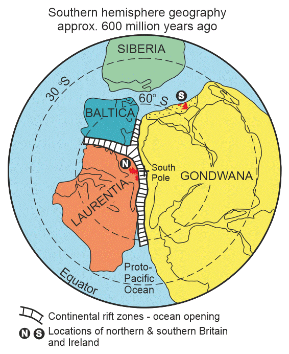
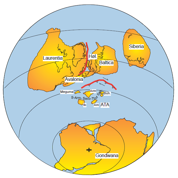
From about 750 Ma the Rodinia supercontinent began to break up. Shown here is the southern hemisphere view of this process at about 580 Ma. Outlines of some present day features are indicated for reference such as Greenland and the Great Lakes on Laurentia and the shorelines of Africa, South America, and Antarctica. Of particular relevance to the Lake District story are the positions of northern [N] and southern [S] Britain and Ireland highlighted in red though detailed terrane information is not specified here. Adapted from K. Jones & S. Blake SXR339 Course Team 2003 Mountain Building in Scotland Open University.
In contrast to the passive margins of Laurentia and Baltica, the Gondwanan margin that includes southern Britain and southern Ireland had been an active continental margin for much of the latest Proterozoic and was comparable to the recent tectonics of the west coast of South America. Typical behaviour of such subduction margins includes back-arc spreading rifting small slivers of continent away from the main landmass, localized collisional events, and varying degrees of strike-slip/transform displacements. All of these processes were responsible for creating a complex collage of continental fragments but in the Lake District, because we have no rocks representing this phase, we can largely, but not completely, overlook these complications. The sum total of these events created the basement to our rock record. Oceanic lithosphere rarely lasts for more than 200 million years [myr] but the Iapetus lithosphere was destined to be vastly more short-lived than most and this has led to a novel Plate Tectonic model proposed by John Waldron and colleagues in 2014. In the early days of Plate Tectonics, closing oceans was seen as involving large continental blocks similar in scale to the present-day sizes of continents. As more work was done it became evident that the process was much messier with small fragments of non-subductible materials [pieces of continent, island arcs, accretionary prisms, etc.] being caught up in the collision zones as terranes. Such orogenic belts take a lot of unravelling and the one the containing the Lake District is proving to be no exception. The various crustal fragments that came from the north margin of Gondwana are referred as peri-Gondwanan terranes and equivalent crustal fragments derived from Laurentia are peri-Laurentian terranes.
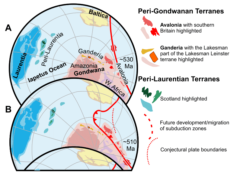
In order to initiate subduction of the young Iapetan oceanic lithosphere Waldron et al. [How was the Iapetus Ocean Infected with Subduction? Geology, vol. 42, pp. 1095-1098] have developed a model based on modern activity in the Caribbean. [A] shows the palaeogeography once Iapetan rifting had reached its maximum extent. The continental fragments destined to become Ganderian terranes are outboard from the Amazonian part of Gondwana [Lakesman Leinster terrane highlighted] and those of Avalonian affinities [Britain south of the Menai Strait highlighted] are off West Africa [B] shows the initiation of a Caribbean style subduction system which involves a major transform fault array to move the Avalonian terranes along the Gondwanan margin.
For several decades the peri-Gondwanan elements were thought to have rifted off Gondwana and drifted directly across Iapetus to collide with Laurentia. Bear in mind that the collision takes place at more or less the same pace as fingernail growth. In a significant departure from several decades of portraying this mode of terrane passage across Iapetus, Waldron and colleagues have developed a model that accounts for the unusually early inception of subduction in Iapetus and many other features of the Caledonian orogenic belt. For those aware of earlier models a striking departure is the upside down starting position of southern Britain as is seen when the first two diagrams are compared. The Waldron et al. model is based on the way that the Caribbean Plate extended into the Atlantic. It is also comparable to the Scotia Plate and to a similar process that may be starting off SW Iberia. Of these three current analogues the Caribbean is the best guide as to how Iapetus might have behaved. Despite there being several contrasting models for its tectonic growth, the extent of transform faults bounding the north and south margins of the Caribbean Plate is perhaps best explained by the westwards drift of North and South America engulfing a slab of Pacific Ocean lithosphere in the gap between them.
The Lake District is part of the Lakesman-Leinster Terrane [LLT] which is bounded to the north by the Iapetus Suture closely following the Solway Firth and its southern boundary is approximately defined by projecting the line of the Menai Strait eastwards. In the diagram modified from the work of Waldron et al. the LLT is shown in orange which hopefully allows it to be tracked through the major stages in its evolution. Being a small player at the scale of the orogenic belt it is difficult to highlight the LLT and at the same time show its role in the evolution of the whole mountain belt. Modern provenance studies [mainly ages of detrital zircons] have allowed original positions of various crustal fragments/terranes in the Caledonian Orogen to be fairly-closely determined. These studies have led to the peri-Gondwanan terranes that were originally close to South America being identified as Ganderian whereas those once close to west Africa are Avalonian. Southern Britain south of the projected Menai Strait line is Avalonian but the LLT is Ganderian. Until southern Britain and the Lake District pulled away from Gondwana they were receiving distinctly different sediment from their adjacent parts of Gondwana. Africa was laced with multiple orogenic belts in the latest Neoproterozoic to early Cambrian and this is reflected in the age profile of detrital zircons in sedimentary rocks with that provenance.
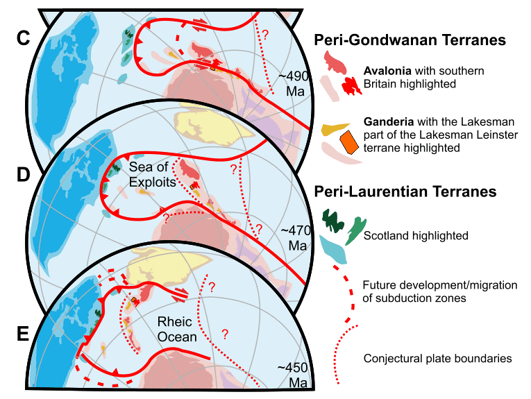
The second part of the diagram from Waldron et al. [2014] showing the Caribbean model for the Lower Palaeozoic evolution of the North Atlantic region. [C] by 490 Ma southern Britain was in contact with the Lakesman-Leinster Terrane [D] by 470 Ma this composite terrane had rifted away from Gondwana and was in a drift phase [E] by 450 Ma Iapetus was significantly reduced in size and subduction was active along the southern margin of Scotland.
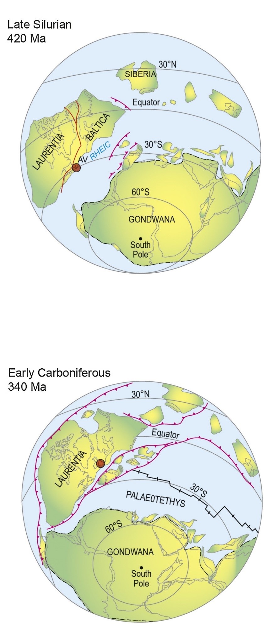
Southern Britain did not reach its present position relative to the LLT until late in the Tremadocian at about 480 Ma. Somewhere around 530 Ma the Gondwanan active continental margin started to be converted into a transform fault system. A characteristic of such major fault belts is that curvature develops and where the sense of strike slip [left or right] and the sense of curvature [stepping] are in unison you create gaps [tension]; where they are opposite there is compression. The sinistral Dead Sea Fault system is a classic example of this pattern of behaviour in the modern world; where it steps to the right there is compression forming mountains [Golan Heights] and a large hole has opened to create the Dead Sea where it steps left. On a broader scale the relative motions between the tectonic plates might have had a component of convergence leading to a boundary dominated by strike-slip coupled with compression. Such boundaries are known as transpressive and the opposite where strike-slip is combined with extension is transtension. At 530 Ma Britain south of the projected Menai Strait line, and the region that was to become the LLT, were both at the northern edge of Gondwana and not far from the South Pole. Then the transform fault came on land into Gondwana it became more like the San Andreas; in doing so it started to move southern Britain towards the Lakesman-Leinster Terrane bringing them into contact at about 480 Ma in a compressive event recorded in rocks on Anglesey and in the Ingleton area. This compressive deformation is equivalent to the Penobscot Orogeny in North America taking its name from a locality in Newfoundland. Accepting the evidence from Eycott Hill about the age of the oldest Skiddaw Group deposits means that the Lake District rock record starts before the Penobscot event but you only see evidence for this deformation in the Ingletonian rocks of the Craven Inliers. Just taking the age evidence from well-documented parts of the Skiddaw Group would mean that the earliest part of this sequence formed at the same time as the Penobscot. Having welded together the LLT became part of the Avalonian Superterrane and it started to pull away from Gondwana in a rifting event in the latest Tremodocian. By earliest Floian times the superterrane had separated from Gondwana and had entered its drift phase with Skiddaw Group sediments being deposited until close to the transition into an active continental margin which created the Borrowdale and Eycott volcanics. Outer shelf to deeper water deposits are the only Skiddaw Group materials preserved which means that only a limited picture can be gained of the sedimentary basin. Of some help in this study is the nature of some major faults within the Skiddaw Group which probably represent major extensional faults formed during rifting. Also a catastrophic slope failure probably marked the edge of a fault-bound secondary basin and the transport direction gives information about the basin geometry. A large clockwise rotation [>130o] of the Lake District is involved in the tectonic model applied here. Therefore, when we determine palaeocurrents and slump directions to give palaeoslope orientations in present-day coordinates, to get an idea of basin configuration, we have to rewind plate motions to the time of deposition.
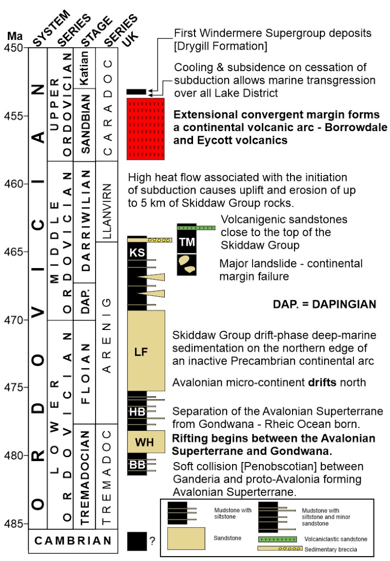
Timescales and simplified logs for the main components in the early evolution of the Lake District. The stages are internationally defined; the local UK terminology is shown to allow comparisons with older publications. The Penobscotian Orogeny was caused by the collision between the Lakesman-Leinster Terrane and Avalonia. The ? denotes the probable Cambrian acritarch microflora at Eycott Hill. BB = Bitter Beck Formation, WH = Watch Hill Formation, HB = Hope Beck Formation, LF = Loweswater Formation, KS = Kirk Stile Formation, TM = Tarn Moor Formation which overlies the Buttermere Formation.
In an interval of around five million years the process of initiating subduction along the Iapetus Ocean margin of Avalonia caused considerable uplift and erosion of Skiddaw Group rocks. It is suggested that as much as five kilometres was eroded before the first Borrowdale/Eycott volcanic deposits were laid down. Processes and mechanisms involved in starting subduction are much debated but higher heat flows were probably responsible for the significant uplift inferred at the Skiddaw/Borrowdales + Eycott volcanics unconformity with the latter over broad areas having been deposited on a fairly planar surface. Earlier suggestions of compressional deformation of orogenic proportions to account for this unconformity have now been shown to be incorrect. A conceptual challenge is posed by the next major Lake District event. An active continental margin involves plate convergence; in our case Iapetus lithosphere converging on the plate carrying Avalonia. It might be expected that a destructive/convergent plate boundary would create a compressive regime but many are in tension and this was certainly the case for the Borrowdales and their time equivalents the Eycott volcanics. An extensional setting explains the conundrum of the tremendous thickness of the Borrowdale volcanic pile perhaps as much as eight kilometres, even though it all formed in a non-marine environment. If the Earth’s surface is subsiding, because of the stretching of the lithosphere, at about the same rate as the accumulation of the volcanics, the sub-aerial style can be maintained. The next challenge is to explain the stupendous volume of the Borrowdales and Eycott volcanics which is either the greatest or joint greatest magmatic event in the entire three plus billion years history of the British Isles. An allied question is why was so much magma produced in such a short time span. It is likely that all the igneous activity took place in one magnetic polarity interval of about five million years. One possible explanation for these first-order features is that the ocean ridge in Iapetus was subducted under the Lake District. Such events are known to greatly enhance rates and volumes of magma generation and also to provide a mechanism to put an end to the magmatism. Such conditions were needed because the upper Borrowdales alone had eight or nine calderas that each released 100s if not 1,000s of cubic kilometres of felsic to intermediate pyroclastics on top of two to three kilometres of andesitic lava flows.
Timescales and simplified logs for the interval between the Borrowdale/Eycott volcanic episode and the Acadian Orogeny. Because the vertical scale is time the rapid sedimentation in the younger Windermere Supergroup is not evident. Deposition continued into the Devonian before the orogeny but all the pre-Acadian Devonian rocks were eroded because of the mountain-building uplift.
An alternative explanation for the cessation of magmatic activity is that it was triggered by the coalescence of Avalonia and Baltica but this amalgamation of crustal elements probably happened a bit later. Baltica as a sedimentary source is distinct especially when detrital zircons are examined. From these data it is evident that Baltica sidled up to [collided if you will] Avalonia just before the elimination of Iapetus as shown by the earlier Baltica signature in the Windermere deposits of the Craven Inliers. A gentle amalgamation of Baltica and Avalonia came about because they were both heading towards Laurentia at more or less the same speed on only slightly differing trajectories, hence again no major orogeny was associated with the event.
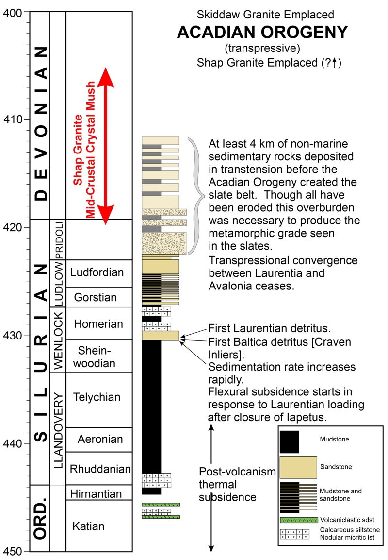
Once the subduction under Avalonia ceased magma was no longer being supplied to the lithosphere beneath the Lake District which cooled leading to contraction and subsidence. Because the extensional tectonic regime had kept the sub-aerial volcanic pile just above sea level, the cooling quickly led to a marine transgression over the whole of the Lake District and the start of Windermere Supergroup sedimentation. The marine planation created an angular unconformity but the origin of this boundary is somewhat unusual in that the structures truncated by the surface of unconformity were generated by piecemeal caldera collapse as opposed to any orogenic process. Thermally-controlled, post-volcanic, subsidence is slow as recorded in the first 15 to 20 million years of Windermere Supergroup deposits. Apart from a couple of minor magmatic episodes the first phase of sedimentation evolved from products of shore-line through shallow shelf to deep shelf environments. This interval represents about half of the life span of the Windermere Supergroup sedimentary basin but only about 15% of the thickness of the basin fill; a critical observation that leads us to what is perhaps the most mis-represented episode in Lake District history. It is clear that about halfway through the Wenlock the sedimentation rate accelerated rapidly. This was realized in 1983 and careful analysis of the rates in 1991 confirmed the basin-generating mechanism as being lithospheric loading to create a foreland basin. Soft docking [collision if you will] of Avalonia against Laurentia to form Laurussia provided the load as the thinned leading edge of Avalonia was partially subducted under the huge Laurentian continent. A clear consequence of this interaction was the elimination of the ocean between the two continental masses – the death of Iapetus in absolute age terms happened about 435 Ma though some researchers place the closure at about 442 Ma. No orogeny [mountain building] was associated with this event yet even in the late 2010s accounts, nearly thirty years behind the science, were still being published attributing the Acadian Orogeny to this ocean closure. The orogeny was more than 25 million years after Iapetus was lost.
Palaeogeography at 430 Ma in the mid Silurian soon after the docking of the Avalonian Superterrane with Laurentia and the elimination of the Iapetus Ocean. From: Conall Mac Niocaill www.earth.ac.uk/~conallm/430ma.pdf
After the initial contact between Avalonia and Laurentia the rate of plate convergence slowed but did not stop until somewhere around the Ludlow/Pridoli boundary which is where our rock record ends with a return to shallow water sedimentation. Until then from the mid-Wenlock the sedimentation rate had been extremely high depositing over four kilometres of mainly turbidites in deep water. Despite losing our rock record we have a clear line of reasoning that requires a continuation of sedimentation for some millions of years even though it has all been eroded without trace. All the Windermere rocks are metamorphic expressed as mineral transformations and the development of structural fabrics. From the metamorphic grade we know that the youngest deposits of the supergroup had to have been buried under kilometres of latest Silurian and earliest Devonian rocks. Estimates of this lost cover vary from as little as three to as much as eight kilometres and it would have covered the entire Lake District; over the National Park at a minimum estimate this would have amounted to 18,000 billion tonnes of rock removed by erosion. Because plate convergence had stopped we need a mechanism to create the basin to receive the sediments and this appears to have been a combination of strike-slip and extension that affected a broad region on both sides of the Iapetus suture [trans suture]. This was a sinistral transtensional regime that opened up sedimentary basins probably in a continental non-marine setting laying down fluvial sediments; we see some of this in the Cheviots. The structures operating at this time tapped magmas that have been attributed to lithospheric delamination which happened when the subducted Iapetus slab dropped off into the asthenosphere. Something remarkable is required to explain several major regional features including the trans-suture suite of granitic intrusions. One of these granites has revealed an astonishing aspect of granite magmatism in the region. A mid-crustal crystal mush was present for around 20 million years from ~420 to 400 Ma as recorded in magmatic zircon grains in the Shap Granite. This mush zone was tapped to take magmas to their final emplacement position in the Skiddaw and Shap areas. These two granites provide key information on the timing of the Acadian Orogeny as they both were intruded late in the development of the slaty cleavage. Because these two granitic bodies are not far apart and both had the same relationship with the tectonic fabric it seemed likely they would have similar radiometric ages. However the current view is that Shap was emplaced significantly earlier at 405.2±1.8 Ma whereas Skiddaw is dated at 398.8±0.4 Ma. Zircon crystals are typically complexly zoned and current analytical techniques can’t extract ages from the latest, very-thin zones that commonly rim the grains so it is possible that the Skiddaw and Shap final emplacement ages might eventually be shown to be contemporaneous.
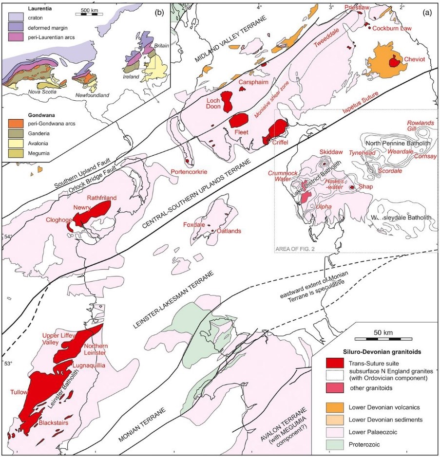
Geology of the Iapetus Suture zone emphasizing the Trans Suture Suite of granitic intrusions. The Figure 2 referred to is the next but one diagram. Figure 1 Woodcock et al. 2019 Proceedings of the Yorkshire Geological Society, vol. 62, pp. 238-253. Open Access article, Creative Commons Attribution License [http://creativecommons.org/licenses/by/4.0/].
The Acadian Orogeny was something of a tectonic anticlimax as well as being something of an enigma. Until recently it was thought that the orogeny produced mountains on the scale of the Alps but the low degree of metamorphism does not support this assertion. A slate belt was the main product of the orogeny but this only requires low-grade regional metamorphism and moderate crustal thickening. Susceptible rocks, originally mud grade, were shortened by 50 to 70% to create slate but this doesn’t happen everywhere and the overall shortening was less than this which limits the amount of crustal thickening which in turn limits the intensity of metamorphic transformation and the height of the mountains. Topography at the end of the orogeny was not too much more than the present-day scale. More of a challenge is what generated the shortening? It was not the soft-docking of Avalonia onto Laurentia because that happened more than 25 million years earlier. It may have been a small continental terrane in the Rheic Ocean that provided the push to create the slate belt or it may have been shallow angle subduction of Rheic Ocean lithosphere under the combined Avalonian and Laurentian continent. Active continental margins, where young lithosphere is being subducted, are in compression because the subduction angle is typically not much more than 15 degrees. Such a geometry transmits compressive stress into the plate that stays at the surface resulting in deformation. As yet there is no definitive evidence supporting either mechanism though collision is more likely explanation.
Palaeogeography early in the Carboniferous when plate activity well to the south of Britain was stretching the lithosphere in the Lake District and there was a narrow ocean off Cornwall and Devon. The red dot is over southern Britain. From Pharaoh [2018] The Anglo-Brabant Massif: persistent palaeo-relief at the heart of Western Europe, Proceedings of the Geologists’ Association, vol. 129, pp. 278-328.
In terms of the Lake District proper – the National Park – we have now covered, at least by area, the great bulk of the geology. To understand how later events impact on the Lake District we have to broaden the geographic remit to consider all of Cumbria and sometimes further afield. From the end of the Acadian Orogeny at about 400 Ma until near the start of the Carboniferous which begins at 359 Ma there are very few Devonian deposits in the Lake District. Somewhere in this interval localized patches of conglomerate, deposited in desert conditions, were formed [Mell Fell conglomerate] probably in erosional features along major faults. A major change in tectonics towards the end of the Devonian can only be fully appreciated on a northern England scale whilst taking into account events in southern England. Close to the end of the Devonian, throughout northern England, the lithosphere was stretched north-south and this tensional stress was applied somewhat pulsatory over the next 40 million years. Subduction along the southern margin of Laurussia caused the extension which created down-dropped troughs bounded by reactivated major faults separated by upstanding areas. In the rest of the world these would be referred to as horst and graben structures but in northern England the terminology is block and basin. Dramatic differences were created between coeval sedimentary deposits on the blocks and in the troughs. Carboniferous strata on the blocks were condensed, shallow-water, locally-emergent, and carbonate-dominated whilst in the troughs much thicker sequences had a deeper-water, basinal, signature such as turbidites. The Lake District was on a block and the common view is that it remained buoyant because of the great thickness of low-density granite that underpins the Central Fells. However, work in 2019 by Howell and colleagues suggests that the block and basin arrangement is more to do with the location of major structures in the basement. Once the extensional stress faded in the late Visean [~335 Ma] the thermal structure of the lithosphere tended towards its original geothermal gradient leading to post-rift thermal subsidence and more uniformity in depositional settings. It is believed that deposition over the entire Lake District started with the thermal phase of subsidence. Post Visean deposits are very minor to the south of the Lakes but in the northwest a more extensive rock record takes the region’s history through to the next orogenic event at the end of the Carboniferous. Early in the thermally controlled subsidence phase [Namurian in age] glacially-driven eustatic fluctuations in sea level interacted with the slow settling of the basin floor to create cycles on a variety of scales. The product is known as the Yoredale facies where deposits reflect cycles from shallow marine through marginal marine to deltaic and finally to terrestrial. After Devonian peneplanation of the Caledonian mountains in Scotland, Greenland, and Norway, they were rejuvenated in the late Visean to early Namurian becoming sources of coarse sandstones in major river systems over 1000 km long. It took time for these rivers to propagate southwards eventually producing, in the early Westphalian, extensive peat deposits on a low-lying plain that covered vast areas of Western Europe. Transformation of these carbon rich layers into coal formed perhaps the most economically significant rock units in the UK – the Coal Measures. Progressive northward movement of Laurussia took the Lake District into more arid regions and, though the depositional environment did not change significantly [fluvial terrestrial], peat horizons became thinner and rare.
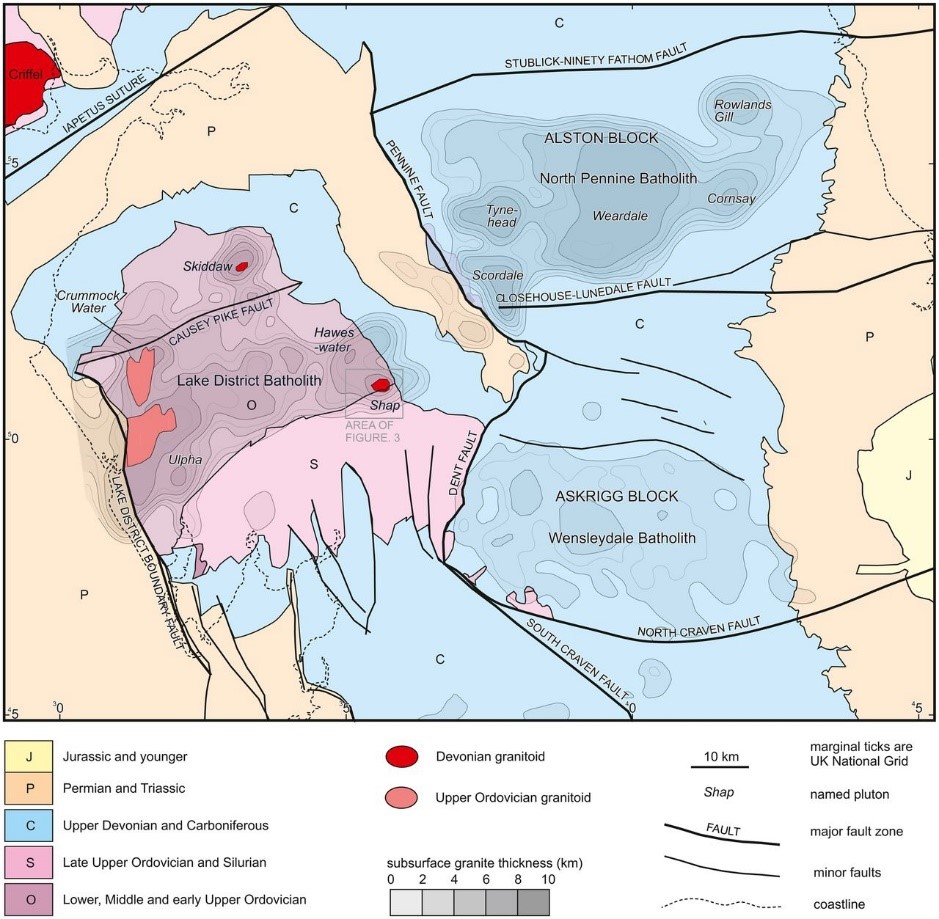
Outline geological map of northern England showing main rock units and major faults overlain on thickness contours of subsurface granite batholiths. The Figure 3 referred to is not used on this web site. Figure 2 Woodcock et al. 2019 Proceedings of the Yorkshire Geological Society, vol. 62, pp. 238-253. Open Access article, Creative Commons Attribution License [http://creativecommons.org/licenses/by/4.0/].
In the latest Westphalian, collisional orogenesis on the southern margin of Laurussia started to impinge on the Lake District. Though these were only far-field effects of the Variscan Orogeny, very locally, and mainly along major faults in the basement, deformation involved overturning of beds. In the Lake District open folding and low dips are the most common expression of this deformation in Carboniferous rocks with variable reactivation of syn-depositional extensional faults with a reverse sense of movement [basin inversion]. Despite being fairly-minor, the structural effects were enough to cause extra expense in underground coal mining becoming a significant factor leading to mine closures. Overall the main phase of deformation was approximately north-south compression but the influence of major basement structures meant that locally stresses were deflected and shear zones parallel to the underlying structural inheritance created an array of fold and fault orientations. In addition to the initial north-south compression a later, less significant, phase of east-west shortening was responsible for deformation in northern England and though the two phases possibly formed a continuum in time radiometric dating indicates a hiatus between them. A recent model has suggested that the east-west compression was generated as a very-broad area, at least on the scale of northern England, was undergoing transtension. A dextral shear zone with boundaries trending ENE-WSW can resolve stresses to generate east-west compression if the shear zone boundaries are moving apart. The resulting structures include the Silverdale Disturbance and mineralized veins in the North Pennines Orefield. Whin Sill magmatism was synchronous with this deformation episode which is dated at about 295 Ma, early in the Permian. At the end of the orogeny plate motions had taken Britain to around 10o north and would be a further twenty degrees further north by the early Triassic.
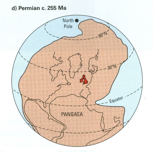
Palaeogeography at about 255 Ma in the late Permian after the Variscan Orogeny highlighting the landlocked position of Britain and Ireland. Extracted from P912314 Earthwise. [Figure 3 in Stone, P, McMillan, A A, Floyd, J D, Barnes, R P, and Phillips, E R. 2012. British regional geology: South of Scotland (Fourth edition). Keyworth, Nottingham: British Geological Survey].
Variscan tectonism ended early in the Permian followed by a period of post-orogenic stress and thermal relaxation. Widespread peneplanation under desert conditions occupied all of the early Permian and probably part of the mid-Permian. At this point we came under the influence of a major rift system that had propagated from the Arctic as the earliest expression of Atlantic rifting. Northern England west of the Pennines was right at the southern tip of this rift system which later in the Permian allowed marine waters to invade our region. Assessments of the stretching direction vary from east-west to 060-240o and the effects are well seen on the Ulverston BGS map sheet with a series of normal faults trending 120-300o. As is always the case with an area that has such a complex history the lithosphere is highly anisotropic and pre-existing weaknesses will be reactivated and there is no simple relationship between stress orientation and faulting. Horst and graben structures were created with alluvial fans and flash-flood breccias deposited along fault scarps. Away from the structural margins, the basins in the Irish Sea and the Vale of Eden filled with desert sediments. Thick accumulations of windblown sands were intercalated with minor amounts of fluvial sands. Continuing subsidence led to marine flooding forming a shallow evaporitic sea which persisted until the end of the Permian. Throughout the Permian the Lake District Block persisted as a topographic high supplying sediment. Permo-Trias extension occurred in two phases the second starting at the Permian Triassic boundary and this latter main phase set the region on the familiar path of rifting followed by thermal sag to control sedimentation. This second stretching event returned the region to terrestrial conditions which started with major river systems sourced in the remnants of the Variscan mountains in southern Europe around 400 km to the south. A key feature of this time interval is that eventually the topographic effects of the rifting were eliminated and Triassic sedimentation spread over the entire Lake District Block. Desert conditions lasted until near the end of the Triassic when a marine transgression marked a change of depositional style which persisted into the Early Jurassic.
This marks the end of the rock record for Cumbria but all is not lost as several lines of evidence allow us to get idea of what was going on geologically in the region. We know that around 1,500 m of rock was covering the basement rocks of the Lake District Block by the end of the Cretaceous 65 to 70 million years ago. Ghost [eroded] deposits leave their mark by how their weight compacts lower rocks, and/or the increase in temperatures this overburden creates. Upping the temperature increases the crystallinity of organic materials in the rocks, cooks microfossils, and anneals radiation damage trails produced in apatite grains. The latter is known as fission-track analysis and when combined with the other techniques gives a reasonable estimate of the temperature reached by the rocks that were underneath the missing cover. Jurassic sedimentation was waning so we cannot call on much rock of this age to provide the answer especially as we have evidence from elsewhere in Britain for widespread erosion before the start of the Cretaceous. This erosional episode commonly known as the late Cimmerian unconformity removed Jurassic and Triassic rocks from over the Lake District Block but left around 900 m of the Triassic succession. For much of the Cretaceous the Lake District was an emergent area but by about 100 Ma only the highest parts of Scotland and Wales were above sea level as Chalk was being deposited in a belt stretching thousands of kilometres latitudinally. From the burial studies we know that approximately 600 m of Chalk was deposited over the Lake District.
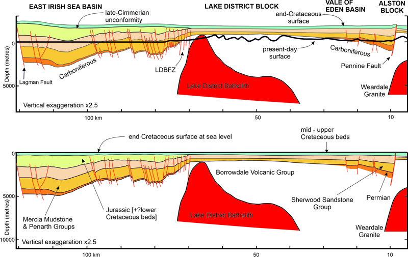
Cross section through Sellafield from offshore in the Irish Sea Basin to the Alston Block. [A] shows the present day situation with the putative eroded overburden [B] is restored to the inferred end Cretaceous position. Adapted from: RA Chadwick, GA Kirkby, HE Baily, 1994, The post-Triassic structural evolution of north-west England and adjacent parts of the East Irish Sea. Proceedings of the Yorkshire Geological Society, vol. 50, pp. 91-102.
We now came under the influence of the Iceland Plume which is part of a vast Large Igneous Province. Uplift over a large area was generated by the dynamic rise of the plume as well as thick magmatic underplating by igneous rock over much of the North Atlantic. The long-term regional uplift lasted about 30 myr starting around 68 Ma with more local episodic uplifts related to small-scale mantle convection features. Sea-floor spreading started in the North Atlantic at 55 Ma and by this time the general outline of modern Britain and Ireland had been defined. Tectonically the UK has not been passive in the Cenozoic and there have been four major exhumation episodes since North Atlantic opening began though these events have left little imprint on the Lake District. Both the Iceland Plume and the North Atlantic rifting could have caused the removal of the Mesozoic cover over the Lake District but some interpretations place this event as young as Middle Pliocene at about 3 Ma. Ductile flow of the upper mantle and lower crust has been invoked as the driving force for this event though the inherited fabric of the basement may have played a major role.
Our last mega-event was the Pleistocene glacial episode which drove massive landscape change by reshaping topography already established by river erosion. By 34 Ma global climate had deteriorated to such an extent that we had entered a worldwide icehouse phase marked by widespread glaciation on Antarctica. The cooling trend continued with large-scale glaciation being established on Greenland at 12.7 Ma culminating with the start of the Quaternary at 2.588 Ma. A striking climatic pattern is seen in the last three million years in the trend towards longer and more extreme periods of global cooling. In the last million years the Lake District was covered by major ice sheets at least three times. Before that the evidence becomes weaker because each event largely removes deposits from previous episodes but it is likely that in the early Pleistocene [2.588 to 0.78 Ma] glaciers were active in the Central Fells in many of the cold stages. Landscape modification [“geomorphological work”] is at its greatest during the cold stages and recently it has been suggested that it peaks under periglacial conditions and the next glacier largely sweeps away the resulting detritus. Whatever the erosional process we have been left with a massively sculpted upland landscape and lowlands plastered with material removed from higher ground. Each major continental ice sheet was responsible for around a global 120-130 m lowering of sea level.
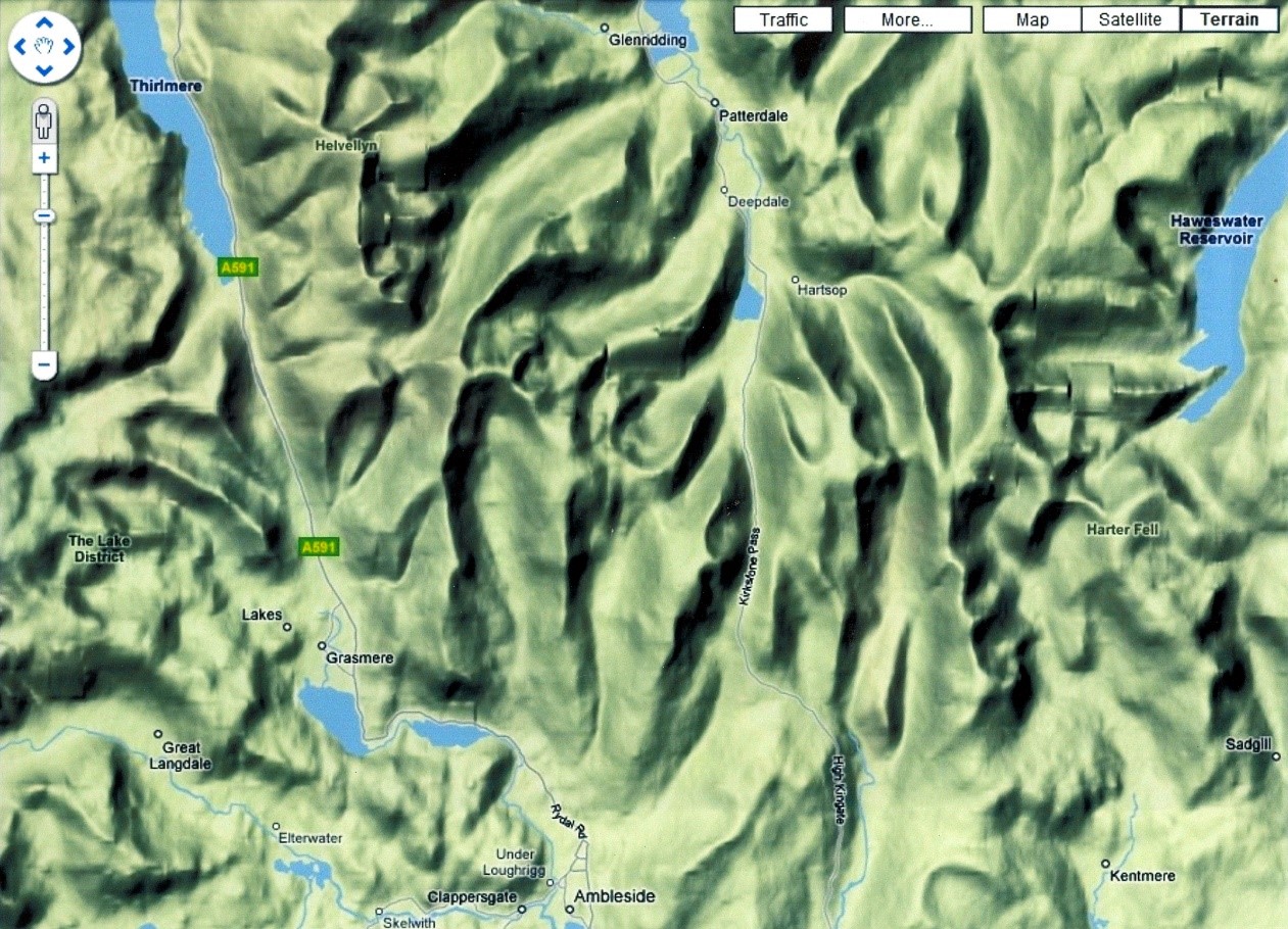
Google Terrain Map highlighting the classic glacial erosional landforms in the Central Fells
The last ice sheet to cover the whole of the Lake District reached its maximum at 27 ka and had disappeared by 15 ka but the post-glacial warming trend was abruptly interrupted by a cooling phase known as the Loch Lomond Stadial [Younger Dryas] from 12.9 ka to 11.7 ka. The extent of the re-advance has been significantly reassessed recently. Previously it was believed to have been restricted to corrie/cirque/cwm/comb/cove, and limited valley, glaciers but in the Lake District there is much evidence for fairly extensive plateau ice-fields around 50-100 m thick which fed ice to lower levels where it would not have otherwise accumulated.
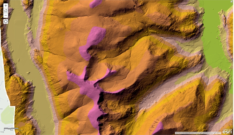
LiDAR image of the Helvellyn Massif highlighting the cirques on the east flanks and the arêtes of Striding and Swirral Edges. Geomatics LiDAR Composite WMS Feed Map, Environment Agency, Open Government Data Licence.
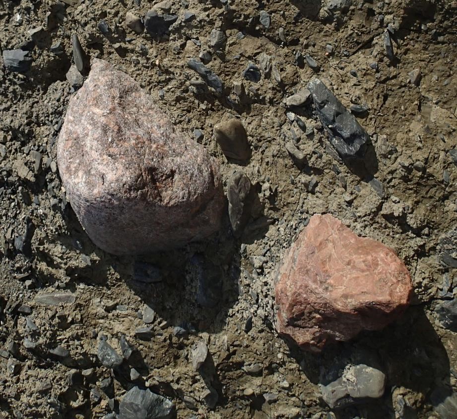
Glacial till in Borrow Beck, the Westmorland Borrowdale valley; boulders set in a clay matrix. Clast composition reflects local derivation being Shap Granite with distinctive megacrysts, brick red microgranite from the Shap dyke swarm, and andesite from the Borrowdale Volcanic Group. The large Shap Granite boulder is approx. 20 cm.
The start of the current interglacial, the Holocene, at 11.7 ka was marked by a very abrupt increase of 8oC in summer temperatures over an interval of around 100 years. After the glacial period, the bare earth was devoid of vegetation and open to intense river erosion. Steep ground was unstable, prone to landslides, and debris flows were common. Progressively plants colonised the region as climatic belts approached the present-day pattern. After the load exerted by the ice sheet was removed, the Earth’s surface rebounded in a glacio-isostatic response which makes factorizing these effects and eustatic sea-level changes a challenge.